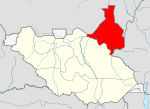
Malakal County
Appearance
Malakal | |
|---|---|
 | |
| Country | South Sudan |
| State | Eastern Nile |
Malakal is a county in the Eastern Nile state. Previously, it was a part of Upper Nile, South Sudan.[1][2][3]
References
- ^ "Referendum results: Upper Nile". Southern Sudan Referendum 2011. Retrieved 2012-01-30.
- ^ "Full list of Kiir's proposed new 28 states in S Sudan". Radio Tamazuj. 3 October 2015. Retrieved 14 August 2016.
- ^ "East Nile governor create three counties, removes Pigi County Commissioner". Radio Tamazuj. 25 April 2016. Retrieved 14 August 2016.

