Mayday, Colorado
Appearance
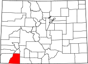
Mayday is an unincorporated community in La Plata County, Colorado, United States. It was named for the Mayday Mine, and is now considered to be a ghost town.[1]
Geography
Mayday is located at 37°21′02″N 108°04′36″W / 37.35056°N 108.07667°W (37.350554, -108.076741).[2] It lies 8733 feet (2662 m) above sea level.
References
- ^ "Mayday - Colorado Ghost Town". ghosttowns.com. Retrieved 1 May 2016.
- ^ "Mayday, Colorado". Geographic Names Information System. United States Geological Survey, United States Department of the Interior. Retrieved 2011-03-27.
External links
- Mayday - Colorado Ghost Town at GhostTowns.com

