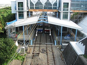
Misakiguchi Station
Appearance
KK72 Misakiguchi Station 三崎口駅 | |
|---|---|
 Misakiguchi Station | |
| General information | |
| Location | 495 Hatsuse-machi Shimomiyada, Miura, Kanagawa (神奈川県三浦市初声町下宮田495) Japan |
| Operated by | Keikyu |
| Line(s) | KK Keikyu Kurihama Line |
| Connections |
|
| Other information | |
| Station code | KK72 |
| History | |
| Opened | 1975 |
| Passengers | |
| FY2011 | 18,039 daily |
Misakiguchi Station (三崎口駅, Misakiguchi-eki) is a railway station on the Keikyu Kurihama Line in Miura, Kanagawa, Japan, operated by the private railway operator Keikyu.
Lines
Misakiguchi Station is the southern terminus of the Keikyu Kurihama Line, and is located 13.4 km from Horinouchi Station, and 65.7 km from Shinagawa Station in Tokyo.
Station layout
The station has two side platforms serving two bi-directional tracks. The station building is elevated and located above the tracks and platforms.[1]
Platforms
| 1-2 | KK Keikyu Kurihama Line | for Yokosuka-chūō, Yokohama, Shinagawa, and Sengakuji A Toei Asakusa Line for Nihombashi and Oshiage KS Keisei Main Line for Aoto and Keisei Takasago |
Adjacent stations
| ← | Service | → | ||
|---|---|---|---|---|
| Keikyu Kurihama Line KK72 | ||||
| Miurakaigan KK71 | Keikyu Wing | Terminus | ||
| Miurakaigan KK71 | Limited Express (Kaitoku) | Terminus | ||
| Miurakaigan KK71 | Limited Express (Tokkyū) | Terminus | ||
History
Misakiguchi Station opened on 26 April 1975.[2]
Passenger statistics
In fiscal 2011, the station was used by an average of 18,039 passengers daily.[2]
References
- Miura, Kazuo. Keikyū Kakuekiteisha to Kamakura Monogatari. Inban Publishing (1998). ISBN 4-8083-0624-7 Template:Ja icon
- ^ Keikyū Misakiguchi Station information Archived 8 October 2006 at the Wayback Machine Template:Ja icon
- ^ a b Terada, Hirokazu (19 January 2013). データブック日本の私鉄 [Databook: Japan's Private Railways] (in Japanese). Japan: Neko Publishing. ISBN 978-4-7770-1336-4.
External links
Wikimedia Commons has media related to Misakiguchi Station.
