Mořkov
Mořkov | |
|---|---|
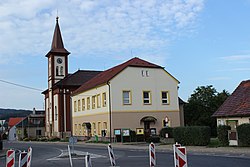
 Centre of Mořkov | |
| Coordinates: 49°32′13″N 18°3′35″E / 49.53694°N 18.05972°E | |
| Country | |
| Region | Moravian-Silesian |
| District | Nový Jičín |
| First mentioned | 1411 |
| Area | |
| • Total | 10.72 km2 (4.14 sq mi) |
| Elevation | 360 m (1,180 ft) |
| Population (2024-01-01)[1] | |
| • Total | 2,430 |
| • Density | 230/km2 (590/sq mi) |
| Time zone | UTC+1 (CET) |
| • Summer (DST) | UTC+2 (CEST) |
| Postal code | 742 72 |
| Website | www |
Mořkov (German: Murk) is a municipality and village in Nový Jičín District in the Moravian-Silesian Region of the Czech Republic. It has about 2,400 inhabitants.
Geography
[edit]Mořkov is located about 7 kilometres (4 mi) south of Nový Jičín and 32 km (20 mi) southwest of Ostrava. The northern part of the municipal territory lies in the Moravian-Silesian Foothills. The southern part lies in the Moravian-Silesian Beskids and also within the Beskydy Protected Landscape Area. The highest point is near the top of the Hodorf hill at 765 m (2,510 ft) above sea level. The stream Králův potok flows through the village. The Jičínka River flows along the northern municipal border.
History
[edit]The first written mention of Mořkov is from 1411, when it was part of the Štramberk estate. Later it was annexed to the Nový Jičín estate.[2]
Demographics
[edit]
|
|
| ||||||||||||||||||||||||||||||||||||||||||||||||||||||
| Source: Censuses[3][4] | ||||||||||||||||||||||||||||||||||||||||||||||||||||||||
Transport
[edit]Mořkov is located on the railway line Valašské Meziříčí–Frýdlant nad Ostravicí.[5]
Sights
[edit]
The main landmark of Mořkov is the Church of Saint George. It was first documented in 1587. In 1878, it was completely rebuilt into its present form.[2]
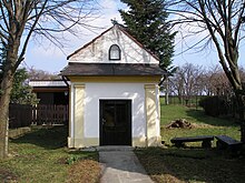
The most valuable monument is the Chapel of Our Lady of Sorrows. It was built in the Neoclassical style in 1853.[6]
References
[edit]- ^ "Population of Municipalities – 1 January 2024". Czech Statistical Office. 2024-05-17.
- ^ a b "Historie" (in Czech). Obec Mořkov. Retrieved 2024-04-18.
- ^ "Historický lexikon obcí České republiky 1869–2011" (in Czech). Czech Statistical Office. 2015-12-21.
- ^ "Population Census 2021: Population by sex". Public Database. Czech Statistical Office. 2021-03-27.
- ^ "Detail stanice Mořkov hl.trať" (in Czech). České dráhy. Retrieved 2024-04-18.
- ^ "Kaple Panny Marie Bolestné" (in Czech). National Heritage Institute. Retrieved 2024-04-18.
External links
[edit]


