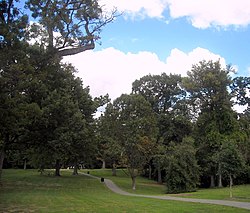
Montrose Park
Appearance
Montrose Park | |
 | |
| Location | R Street and Lovers' Lane, N.W., Washington, District of Columbia |
|---|---|
| Coordinates | 38°54′50.6″N 77°3′42.48″W / 38.914056°N 77.0618000°W |
| Built | 1911 |
| NRHP reference No. | 07001178[1] |
| Added to NRHP | November 15, 2007 |
The Montrose Park is a public park, owned by the federal government, located in the 3000 block of R Street, Northwest, Washington, D.C., in the Georgetown neighborhood. It is located between Dumbarton Oaks Park, and Oak Hill Cemetery.
In addition to a large children's play area in the back of the park, there are two sets of tennis courts, as well as open space with footwalks and trails which lead into Rock Creek Park.
History

It was early owned by ropemaker Robert Parrott, who allowed the community to use it as a picnicing ground. Sarah Louisa Rittenhouse successfully led a group to lobby Congress to acquire the property as an addition to Rock Creek Park. [3]
See also
References
- ^ "National Register Information System". National Register of Historic Places. National Park Service. July 9, 2010.
- ^ "Park is Planned for Georgetown". Evening Star. No. 17, 353. Washington, D.C. 29 March 1908. p. 3 (section 2) – via Chronicling America: Historic American Newspapers. Library of Congress.
- ^ "Washington, DC--Dumbarton Park". Retrieved 11 March 2016.
External links

