
Mount Field (British Columbia)
| Mount Field | |
|---|---|
 Mount Field with Mount Wapta in the background; near Field, British Columbia, Canada. | |
| Highest point | |
| Elevation | 2,643 m (8,671 ft)[1] |
| Prominence | 182 m (597 ft)[2] |
| Listing | Mountains of British Columbia |
| Coordinates | 51°25′51″N 116°27′46″W / 51.43083°N 116.46278°W[3] |
| Geography | |
 Mount Field Location in British Columbia  Mount Field Mount Field (Canada) | |
 | |
| Interactive map of Mount Field | |
| Location | Yoho National Park British Columbia, Canada |
| District | Kootenay Land District |
| Parent range | President Range |
| Topo map | NTS 82N8 Lake Louise |
| Climbing | |
| Easiest route | Scramble |
Mount Field is a mountain located about 4 km (2 mi) northeast of the town of Field in Yoho National Park, Canada. The mountain was named in 1884[4] after Cyrus West Field, an American merchant who had laid the first Atlantic cable, 1858, a second in 1866; Mr. Field was visiting the Canadian Rockies the year as a guest of the CPR who were building the national railway, at the naming of a station and a mountain.[3] Precipitation runoff from Mount Field drains into the Kicking Horse River. Topographic relief is significant as the summit rises 1,360 meters (4,462 feet) above the river in two kilometers (1.2 mile). The Trans-Canada Highway (Highway 1) traverses the southern foot of the mountain.
Geology
[edit]Mount Field is composed of sedimentary rock laid down during the Precambrian to Jurassic periods.[5] Formed in shallow seas, this sedimentary rock was pushed east and over the top of younger rock during the Laramide orogeny.[6] The Burgess Shale is located below the ridge connecting Mt. Field to Wapta Mountain.
Climate
[edit]Based on the Köppen climate classification, Mount Field is located in a subarctic climate zone with cold, snowy winters, and mild summers.[7] Winter temperatures can drop below −20 °C with wind chill factors below −30 °C.
Gallery
[edit]-
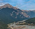 Mount Field rising above Field, British Columbia

See also
[edit]References
[edit]- ^ "Mount Field". cdnrockiesdatabases.ca. Retrieved 2019-08-20.
- ^ "Mount Field". Bivouac.com. Retrieved 2016-07-02.
- ^ a b "Mount Field". BC Geographical Names. Retrieved 2016-07-02.
- ^ British Columbia official naming site
- ^ Belyea, Helen R. (1960). The Story of the Mountains in Banff National Park (PDF). parkscanadahistory.com (Report). Ottawa: Geological Survey of Canada. Archived (PDF) from the original on 2015-10-02. Retrieved 2019-09-13.
- ^ Gadd, Ben (2008). Geology of the Rocky Mountains and Columbias.
- ^ Peel, M. C.; Finlayson, B. L.; McMahon, T. A. (2007). "Updated world map of the Köppen−Geiger climate classification". Hydrol. Earth Syst. Sci. 11: 1633–1644. ISSN 1027-5606.
External links
[edit]- Mount Field in the Canadian Mountain Encyclopedia.
- Cyrus W. Field at the Atlantic Cable history website.
- Weather: Mount Field
This article about a location in the Interior of British Columbia, Canada is a stub. You can help Wikipedia by expanding it. |