
Mount Tengu
| Mount Tengu | |
|---|---|
| 天狗岳 | |
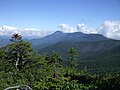
 Mount Tengu from west | |
| Highest point | |
| Elevation | 2,646 m (8,681 ft) |
| Listing | List of mountains and hills of Japan by height |
| Coordinates | 36°01′09″N 138°21′20″E / 36.01917°N 138.35556°E |
| Naming | |
| Language of name | Japanese |
| Pronunciation | [teŋɡudake] |
| Geography | |
 | |
| Location | On the border of Chino and Koumi of Nagano in Japan |
| Parent range | Northern Yatsugatake Volcanic Group |
| Geology | |
| Mountain type | Stratovolcano |
Mount Tengu (天狗岳, Tengu-dake) is a 2,646m mountain on the border of Chino and Koumi of Nagano in Japan. This mountain is the highest mountains of Northern Yatsugatake Volcanic Group.
Description
Mount Tengu is a stratovolcano. This mountain is a part of the Yatsugatake-Chūshin Kōgen Quasi-National Park. This mountain is on the list of the 200 famous mountains in Japan. This mountain has two major peaks, Mount Higashi Tengu, and Mount Nishi Tengu.
Access
Gallery
-
 Mount Tengu from Mount Iō
 -
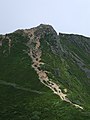
 Mount Nishi-Tengu (Left) and Mount Higashi-Tengu from Mount Neishi
 -
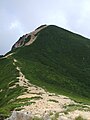 Mount Nishi-Tengu from Mount Higashi-Tengu
 -
 Mount Higashi-Tengu from Mount Nishi-Tengu
 -
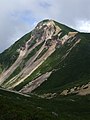 Mount Nishi-Tengu from Mount Neishi
 -
 Kuroyuri-daira, north of Mount Tengu
 -
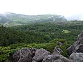 Kuroyuri-daira, north of Mount Tengu
 -
 Mount Tateshina from Mount Tengu
 -
 Hida Mountains from Mount Tengu


