
Muddy Mountains
| Muddy Mountains | |
|---|---|
 Muddy Peak, second highest summit of the Muddy Mountains | |
| Highest point | |
| Peak | Muddy Summit |
| Elevation | 1,657 m (5,436 ft) |
| Coordinates | 36°17′55″N 114°42′51″W / 36.29861°N 114.71417°W |
| Geography | |
| Country | United States |
| State | Nevada |
| District | Clark County |
| Range coordinates | 36°23′33.908″N 114°39′0.960″W / 36.39275222°N 114.65026667°W |
| Topo map | USGS Piute Point |

The Muddy Mountains are a mountain range in Clark County, Nevada.[1]
The Muddy Mountains surround a north section of Bitter Spring Valley, which also lies at the northwest perimeter of the Black Mountains, lying on a north shore of an east-west section of Lake Mead.
-
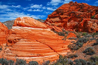 Cross bedding in Aztec Sandstone, Muddy Mountains Wilderness Area
 -
 Muddy Mountains seen from the Valley of Fire State Park, Nevada


References
- ^ a b "Muddy Mountains". Geographic Names Information System. United States Geological Survey, United States Department of the Interior. Retrieved 2009-05-04.
This Nevada state location article is a stub. You can help Wikipedia by expanding it. |