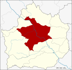
Mueang Kamphaeng Phet district
Mueang Kamphaeng Phet
เมืองกำแพงเพชร | |
|---|---|
 Mueang Kamphaeng Phet Clock Tower located at the entrance of Mueang Kamphaeng Phet close to Wongwian Ton Pho | |
 District location in Kamphaeng Phet province | |
| Coordinates: 16°29′0″N 99°31′12″E / 16.48333°N 99.52000°E | |
| Country | Thailand |
| Province | Kamphaeng Phet |
| Seat | Nai Mueang |
| Area | |
• Total | 1,962.0 km2 (757.5 sq mi) |
| Population (2015) | |
• Total | 213,228 |
| • Density | 108.1/km2 (280/sq mi) |
| Time zone | UTC+7 (ICT) |
| Postal code | 62000 |
| Geocode | 6201 |
Mueang Kamphaeng Phet (Thai: เมืองกำแพงเพชร, pronounced [mɯ̄a̯ŋ kām.pʰɛ̄ːŋ pʰét]) is the capital district (amphoe mueang) of Kamphaeng Phet province, central Thailand.
Geography
[edit]Neighboring districts are (from the northwest clockwise) Kosamphi Nakhon, Phran Kratai, Sai Ngam, Khlong Khlung, Khlong Lan of Kamphaeng Phet Province and Wang Chao of Tak province.
History
[edit]In 1917 the district was renamed Mueang Kamphaeng Phet.[1]
Administration
[edit]Central administration
[edit]The district Mueang Kamphaeng Phet is divided into 16 sub-districts (tambons), which are further subdivided into 220 administrative villages (mubans).
| No. | Name | Thai | Villages | Pop.[2] |
|---|---|---|---|---|
| 1. | Nai Mueang | ในเมือง | - | 29,191 |
| 2. | Trai Trueng | ไตรตรึงษ์ | 15 | 15,095 |
| 3. | Ang Thong | อ่างทอง | 21 | 18,106 |
| 4. | Na Bo Kham | นาบ่อคำ | 22 | 20,074 |
| 5. | Nakhon Chum | นครชุม | 13 | 17,475 |
| 6. | Song Tham | ทรงธรรม | 12 | 7,552 |
| 7. | Lan Dokmai | ลานดอกไม้ | 11 | 6,931 |
| 10. | Nong Pling | หนองปลิง | 11 | 12,338 |
| 11. | Khonthi | คณฑี | 13 | 9,747 |
| 12. | Nikhom Thung Pho Thale | นิคมทุ่งโพธิ์ทะเล | 16 | 9,378 |
| 13. | Thep Nakhon | เทพนคร | 22 | 20,369 |
| 14. | Wang Thong | วังทอง | 21 | 10,819 |
| 15. | Tha Khun Ram | ท่าขุนราม | 13 | 9,065 |
| 17. | Khlong Mae Lai | คลองแม่ลาย | 10 | 7,435 |
| 18. | Thammarong | ธำมรงค์ | 8 | 4,454 |
| 19. | Sa Kaeo | สระแก้ว | 12 | 15,199 |
Missing numbers are the tambon which now form Kosamphi Nakhon District.
Local administration
[edit]There are two towns (thesaban mueangs) in the district:
- Kamphaeng Phet (Thai: เทศบาลเมืองกำแพงเพชร) consisting of sub-district Nai Mueang.
- Nong Pling (Thai: เทศบาลเมืองหนองปลิง) consisting of sub-district Nong Pling.
There are five sub-district municipalities (thesaban tambons) in the district:
- Khlong Mae Lai (Thai: เทศบาลตำบลคลองแม่ลาย) consisting of parts of sub-districts Ang Thong, Khlong Mae Lai.
- Nakhon Chum (Thai: เทศบาลตำบลนครชุม) consisting of parts of sub-district Nakhon Chum.
- Pak Dong (Thai: เทศบาลตำบลปากดง) consisting of parts of sub-district Trai Trueng.
- Thep Nakhon (Thai: เทศบาลตำบลเทพนคร) consisting of sub-district Thep Nakhon.
- Nikhom Thung Pho Thale (Thai: เทศบาลตำบลนิคมทุ่งโพธิ์ทะเล) consisting of sub-district Nikhom Thung Pho Thale.
There are 12 sub-district administrative organizations (SAO) in the district:
- Trai Trueng (Thai: องค์การบริหารส่วนตำบลไตรตรึงษ์) consisting of parts of sub-district Trai Trueng.
- Ang Thong (Thai: องค์การบริหารส่วนตำบลอ่างทอง) consisting of parts of sub-district Ang Thong.
- Na Bo Kham (Thai: องค์การบริหารส่วนตำบลนาบ่อคำ) consisting of sub-district Na Bo Kham.
- Nakhon Chum (Thai: องค์การบริหารส่วนตำบลนครชุม) consisting of parts of sub-district Nakhon Chum.
- Song Tham (Thai: องค์การบริหารส่วนตำบลทรงธรรม) consisting of sub-district Song Tham.
- Lan Dokmai (Thai: องค์การบริหารส่วนตำบลลานดอกไม้) consisting of sub-district Lan Dokmai.
- Khonthi (Thai: องค์การบริหารส่วนตำบลคณฑี) consisting of sub-district Khonthi.
- Wang Thong (Thai: องค์การบริหารส่วนตำบลวังทอง) consisting of sub-district Wang Thong.
- Tha Khun Ram (Thai: องค์การบริหารส่วนตำบลท่าขุนราม) consisting of sub-district Tha Khun Ram.
- Khlong Mae Lai (Thai: องค์การบริหารส่วนตำบลคลองแม่ลาย) consisting of parts of sub-district Khlong Mae Lai.
- Thammarong (Thai: องค์การบริหารส่วนตำบลธำมรงค์) consisting of sub-district Thammarong.
- Sa Kaeo (Thai: องค์การบริหารส่วนตำบลสระแก้ว) consisting of sub-district Sa Kaeo.
See also
[edit]References
[edit]- ^ ประกาศกระทรวงมหาดไทย เรื่อง เปลี่ยนชื่ออำเภอ (PDF). Royal Gazette (in Thai). 34 (ก): 40–68. 1917-04-29. Archived from the original (PDF) on November 7, 2011.
- ^ "Population statistics 2015" (in Thai). Department of Provincial Administration. Retrieved 2016-03-22.
External links
[edit]- amphoe.com (Thai)
