
Mukeshpuri
Mukeshpuri | |
|---|---|
 Snowy Mountains of Mukeshpuri | |
 Mukeshpuri  Mukeshpuri | |
| Coordinates: 34°04′N 73°23′E / 34.067°N 73.383°E | |
| Country | |
| Province | Khyber Pakhtunkhwa |
| District | Abbottabad District |

Mukeshpuri is a 2,800-metre-high (9,200 ft) mountain in the Nathia Gali Hills, in the Abbottabad District of the Khyber Pakhtunkhwa province in northern Pakistan. It is 90 kilometres (56 mi) north of Islamabad, just above Dunga Gali in the Nathia Gali area of Ayubia National Park. Much of it the mountain is covered with Western Himalayan subalpine conifer forests.[1]
Etymology
The name Mukeshpuri is possibly derived from the Sanskrit words: Moksha (liberation) and Puri (city). Mukeshpuri has a special of significance for the Hindus because of the Legends relating it to the Pandavas of the Mahabharata.[citation needed]
There are the five Pandavas, the heroes of the Mahabharata, who are favourite objects of worship in the east and sometimes addressed as the Panj Pir (five saints). Many are the legends current about these heroes and they are localised at quite a number of places. The Hill of Mokeshpuri's name means 'the hill of salvation' and on its summit is a Panduan da Sthan, or place of the Pandavas.[2]
The peak
The route from Nathia Gali on western side of mountain is a steady and 4-kilometre-long (2.5 mi) climb. The mountain also has a route on the Dunga Gali side, with a steeper slope. There is a bird sanctuary on this side created with the help of the European Union.
From the top of Mukeshpuri peak, on the eastern edge of Khyber Pakhtunkhwa, the following areas can be seen: — Circle Bakote, Jhelum River, the Bagh District of Azad Kashmir, in the south the city of Murree and the Murree Tehsil, as well as Islamabad.[3]
Gallery
-
 Mukeshpuri mountain and the Nathia Gali in Ayubia National Park
 -
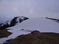 The top of Mukeshpuri peak
 -
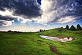
 View from Mukeshpuri
 -
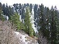 Conifer forests on the mountain.
 -
 Mushkpuri Top


See also
- List of mountains in Pakistan
- Galyat region - the local region and its towns
- Muree - adjacent in the Rawalpindi District
References
- ^ "Location and Covered with Western Himalayan Subalpine Conifer Forests". Bhattiadil.wordpress.com. Retrieved 21 June 2018.
- ^ A glossary of the tribes and castes of the Punjab and North -West provinces, compiled by H A Rose, Vol I Page 120
- ^ "Areas which can be seen from Mukeshpuri Top". www.pakistantoursguide.pk. Retrieved 20 June 2018.
External links
 Murree travel guide from Wikivoyage
This Abbottabad District location article is a stub. You can help Wikipedia by expanding it. |