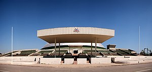
O'Higgins Park
| Parque O'Higgins | |
|---|---|
 | |
 | |
| Type | Urban Park |
| Location | |
| Coordinates | 33°25′42″N 70°40′11″W / 33.42833°N 70.66972°W |
| Area | 80 hectares |
| Created | 1873 |
| Operated by | Santiago |
| Status | Open |
O'Higgins Park (Spanish: Parque O'Higgins, formerly known as Parque Cousiño) is Santiago, Chile's second largest public park (Santiago's Metropolitan Park is the largest). It is located in the center of the capital, in the Santiago Commune. Measuring some 190 acres (770,000 m²), it is about a quarter of the size of Manhattan's Central Park.
The park, named after Bernardo O'Higgins (one of Chile's founding fathers), is a popular place for families to visit during weekends and holidays, especially during the national holiday on September 18, when a number of fondas and ramadas —traditional places for dancing, eating and drinking— are open to the public for a few days.
Since 2011, O’Higgins Park has hosted the annual music festival Lollapalooza Chile.
History

Alberto Orrego Luco


The present-day O’Higgins Park is the result of gradual evolution over its history. The site, originally called Pampilla or El Llano, was a flat open space between the modern-day Santa Rosa and San Ignacio streets, where people gathered to celebrate Fiestas Patrias, Chile’s national day.

The government bought the land in 1845 and used the southern portion for state buildings, including a jail. In 1870, it gave the northern portion of the terrain to Chilean politician, entrepreneur and philanthropist Luis Cousiño. Inspired by the parks he saw in Europe, he decided to create one in his own city and contracted French landscaper Guillermo Renner to shape it into parkland. The park was inaugurated in 1873 and was named Parque Cousiño in his honor.[1]
Movistar Arena
In 1956, work began on an indoor stadium inside O’Higgins Park which would eventually become the largest covered arena in Chile. Construction started but then stalled, leaving only the bare structure of the stadium complete until 1999, when the roof was finally completed. After further delays, the stadium at last opened to the public in 2006 as the Arena Santiago. In 2008, Telefonica’s cellphone division Movistar bought the naming rights and the stadium became the Movistar Arena.[2]
Religious events
On 19 December 1926, the Church in Chile used Cousiño Park for a ceremony to crown an image of Our Lady of Mount Carmel, Chile’s patron saint, led by Benedetto Aloisi Masella, the papal nuncio to the country. The painting used in the ceremony is preserved in Santiago Metropolitan Cathedral and is carried through the streets of Santiago on the last Sunday of September each year.
In 1987, Pope John Paul II visited Chile and led a beatification ceremony in O’Higgins Park for Saint Teresa of the Andes.[3] The ceremony had to be suspended when violence broke out between the Carabineros de Chile (Chilean police force and gendarmerie) and crowds protesting Augusto Pinochet’s military dictatorship. The situation calmed and the pope, believed to be a supporter of Chile’s return to democracy, concluded his address with the words “love is stronger”.[4]
Davis Cup controversy
Controversy returned to O’Higgins Park in 2000, when Chile and Argentina played tie for the tennis Davis Cup in the Arena Santiago. During the second singles match between Nicolás Massú and Mariano Zabaleta, the crowd reacted violently, throwing objects on the court and forcing Argentina to withdraw.[5]
In November 2010, musician and Lollapalooza founder Perry Farrell announced that the first overseas version of the rock festival would take place in O’Higgins Park, Santiago. The inaugural Lollapalooza Chile took place on 2–3 April 2011 and drew a crowd of about 100,000, with venues including the park’s Movistar Arena, La Elipse, and La Cupula Theater. Lollapalooza Chile has returned annually since then, most recently on 14–15 March 2015.[6]
Infrastructure

The park is located next to Parque O’Higgins metro station and near Santiago’s Autopista Central highway.
Key structures and facilities include:
The Movistar Arena, one of the largest multi-use stadia in South America. Campo de Marte, also known as La Elipse (Spanish: the ellipse), where a military parade takes place every September 19 for the Day of the Glories of the Army. El Pueblito (Spanish: little village), where visitors can find shops, craft stalls and museums, including the Museum of the Huaso and the Insect and Snail Museum. Fantasilandia, the biggest amusement park in Chile, located in the park’s northwestern corner. Olimpic pool[7]
There is also a public pool, a roller skating field, a skate park, tennis courts, a soccer field, a theater and an artificial lake, with walking trails crossing the length of the park.
References
- ^ When Parque Cousiño became Parque O’Higgins sentidoscomunes.cl September 14, 2013, retrieved on March 21, 2015
- ^ El "elefante blanco" que se convirtió en epicentro musical economiaynegocios.cl May 09, 2011, retrieved on March 22, 2015
- ^ La convulsionada visita del Papa Juan Pablo II a Chile guoteca.cl retrieved on March 22, 2015
- ^ La batalla del parque O'Higgins El Pais, Madrid, April 05, 1987, retrieved on March 22, 2015
- ^ Tennis chiefs consider sanctions after Davis Cup fiasco The Independent, 10 April 200, sourced 22 March 2015.
- ^ First Lollapalooza Chile latercera.cl D. Lagos - April 09, 2013, retrieved on March 22, 2015
- ^ Prmera piedra de la piscina olmpica latercera June 08, 2012, retrieved on March 22, 2015
External links
33°27′51″S 70°39′36″W / 33.46417°S 70.66000°W
