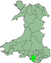
Ogwr
Appearance
| Ogwr | |
|---|---|
 | |
| History | |
| • Created | 1974 |
| • Abolished | 1996 |
| • Succeeded by | Bridgend County Borough |
| Status | Borough |
| • HQ | Bridgend |
The Borough of Ogwr was one of six districts of Mid Glamorgan in Wales, which existed from 1974 to 1996.
It was formed under the Local Government Act 1972 from the urban districts of Bridgend, Maesteg, Ogmore and Garw and Porthcawl, along with Penybont Rural District from the administrative county of Glamorgan. In 1996 most of Ogwr became part of Bridgend County Borough, with the Vale of Glamorgan taking the communities of Wick, St Brides Major and Ewenny.
The district took its name from the local River Ogwr.
51°30′31″N 3°34′42″W / 51.5087°N 3.5782°W
