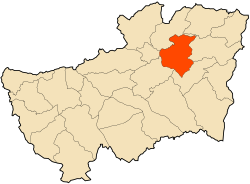
Ouillen
Appearance
Ouillen | |
|---|---|
Commune and town | |
 | |
| Coordinates: 36°19′45″N 8°7′20″E / 36.32917°N 8.12222°E | |
| Country | |
| Province | Souk Ahras Province |
| Population (2008) | |
| • Total | 6,544 |
| Time zone | UTC+1 (CET) |
Ouillen is a town and commune in Souk Ahras Province in north-eastern Algeria.[1]
Settlements
- Aïn Battouma
- Aïn Djenane
- Aïn El Mora
- Aïn Messaouda
- Aïn Safra Remila
- Aïn Tirtri
- Aïn Youcif
- Aïn Zrad
- Berrichi
- Boukebch
- Boulebch
- Bouzaroura
- Dhissa
- Derdara
- Djelida
- Draa Safir
- Etarfaya
- El Battoun
- El Ksor
- El Luiza
- El Mekimen
- Ghoumriane
- Hamman Tassa
- Henchir El Ouachaï
- Khenguet Zaouch
- Ras El Kef
- Sidi Khachine
- Takouka
References
- ^ "Communes of Algeria". Statoids. Retrieved December 12, 2010.
36°19′45″N 8°07′20″E / 36.32917°N 8.12222°E


