Parłówko
Appearance
Parłówko | |
|---|---|
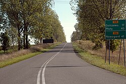
 Beginning of the voivodeship road 108, located in Parłówko, in 2009. | |
| Coordinates: 53°50′43″N 14°44′54″E / 53.84528°N 14.74833°E | |
| Country | |
| Voivodeship | West Pomeranian |
| County | Kamień |
| Gmina | Wolin |
| Time zone | UTC+1 (CET) |
| • Summer (DST) | UTC+2 (CEST) |
| Postal code | 72-511 |
| Area code | +48 91 |
Parłówko[a][1] is a settlement in the West Pomeranian Voivodeship, Poland, located within the Gmina Wolin, Kamień County.[2][3]
Transportation
[edit]In the settlement is located the Parłówko railway stop, located on the railway line 401, between stations of Szczecin Dąbie and Świnoujście Port.[1][4] In Parłówko is also located the intersection between the voivodeship road 107, and voivodeship road 108.[5]
Notes
[edit]References
[edit]- ^ a b "Parłówko". atlaskolejowy.net (in Polish).
- ^ Oficjalny Spis Pocztowych Numerów Adresowych. Warsaw: Poczta Polska. 2022. p. 918. (in Polish)
- ^ "Osada Parłówko". polskawliczbach.pl (in Polish).
- ^ "Parłówko". bazakolejowa.pl (in Polish).
- ^ Polska 2020/2021: mapa samochodowa 1:700 000, Warsaw: Grupa PWN, 2020, ISBN 978-83-65808-36-3. (in Polish)


