
Paulet Island
| Paulet Island | |
|---|---|
 Paulet Island, December 2004 | |
| Highest point | |
| Elevation | 353 m (1,158 ft)[1] |
| Prominence | 353 m (1,158 ft) |
| Coordinates | 63°35′S 55°47′W / 63.583°S 55.783°W[1] |
| Geography | |
| Location | Antarctic Peninsula, Antarctica |
| Geology | |
| Mountain type | Cinder cone[1] |
| Last eruption | Unknown |
 | |
| Geography | |
|---|---|
| Location | Antarctica |
| Coordinates | 63°35′S 55°47′W / 63.583°S 55.783°W |
| Length | 1 mi (2 km) |
| Width | 1 mi (2 km) |
| Administration | |
| Demographics | |
| Population | 0 |
Paulet Island is a circular island about 1 mile (1.6 km) in diameter, lying 3 miles (4.8 km) southeast of Dundee Island, off the northeastern end of the Antarctic Peninsula. It is composed of lava flows capped by a cinder cone with a small summit crater. Geothermal heat keeps parts of the island ice-free, and the youthful morphology of the volcano suggests that it was last active within the last 1,000 years.[1] Paulet Island was discovered by a British expedition (1839–1843) under James Clark Ross and named by him for Captain the Right Honorable Lord George Paulet, Royal Navy.
In 1903 during the Swedish Antarctic Expedition led by Otto Nordenskiöld his ship Antarctic was crushed and sunk by the ice off the coast of the island.
Paulet Island is home to a colony of over 200,000 Adelie penguins, and is a common destination for subantarctic sightseeing tours.
Gallery
-
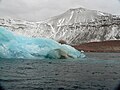 Paulet Island (February 2007)
 -
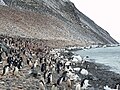 Adelie penguin colony on Paulet Island


See also
- Composite Antarctic Gazetteer
- List of Antarctic and sub-Antarctic islands
- List of Antarctic islands south of 60° S
- List of volcanoes in Antarctica
- SCAR
- Territorial claims in Antarctica
References
Bibliography
- Antarctica. Sydney: Reader's Digest, 1985, pp. 152–159.
- Child, Jack. Antarctica and South American Geopolitics: Frozen Lebensraum. New York: Praeger Publishers, 1988, pp. 69, 72.
- Lonely Planet, Antarctica: a Lonely Planet Travel Survival Kit, Oakland, CA: Lonely Planet Publications, 1996, 302.
- Stewart, Andrew, Antarctica: An Encyclopedia. London: McFarland and Co., 1990 (2 volumes), p 752.
- U.S. National Science Foundation, Geographic Names of the Antarctic, Fred G. Alberts, ed. Washington: NSF, 1980.
- LeMasurier, W. E. (1990). Volcanoes of the Antarctic Plate and Southern Oceans. American Geophysical Union. p. 512 pp. ISBN 0-87590-172-7.
{{cite book}}: Unknown parameter|coauthors=ignored (|author=suggested) (help)
External links
- More information about Paulet Island
- Picture of Paulet Island with thousands of Antarctic Penguins
- Another picture of Paulet Island
- Comprehensive Report about Paulet Island with a lot of pictures
This Graham Land location article is a stub. You can help Wikipedia by expanding it. |