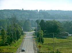
Perry, Ontario
Perry | |
|---|---|
| Township of Perry | |
 Emsdale | |
| Coordinates: 45°30′N 79°17′W / 45.500°N 79.283°W | |
| Country | |
| Province | |
| District | Parry Sound |
| Settled | 1873 |
| Incorporated | 1888 |
| Government | |
| • Type | Township |
| • Mayor | Norm Hofstetter |
| • Federal riding | Parry Sound—Muskoka |
| • Prov. riding | Parry Sound—Muskoka |
| Area | |
| • Land | 187.22 km2 (72.29 sq mi) |
| Population (2016)[1] | |
| • Total | 2,454 |
| • Density | 13.1/km2 (34/sq mi) |
| Time zone | UTC-5 (EST) |
| • Summer (DST) | UTC-4 (EDT) |
| Postal Code | P0A 1J0 |
| Area code | 705 |
| Website | www.townshipofperry.ca |
Perry is a township in the Canadian province of Ontario, located in the Almaguin Highlands region of Parry Sound District.
The township had a population of 2,454 in the 2016 Canadian census.
Communities
- Clear Lake
- Emsdale
- Novar
- Scotia
- Swindon
- Walls
Demographics
Population trend:[2]
- Population in 2016: 2454 (2011 to 2016 population change: 5.9%)
- Population in 2011: 2317 (2006 to 2011 population change: 15.3%)
- Population in 2006: 2010
- Population in 2001: 2252
- Population in 1996: 2215
- Population in 1991: 2049
Private dwellings occupied by usual residents: 966 (total dwellings: 1517)
Mother tongue:[3]
- English as first language: 91.8%
- French as first language: 1.0%
- English and French as first language: 0.5%
- Other as first language: 6.7%
See also
References
- ^ a b 2011 Census Profile
- ^ Statistics Canada: 1996, 2001, 2006, 2011 census
- ^ "2006 Community Profile".
External links
- Emsdale Ontario Almaguin Highlands Regional Portal
- Novar Ontario Almaguin Highlands Regional Portal


