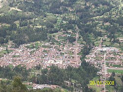
Pomabamba District
Appearance
Pomabamba Pumapampa | |
|---|---|
 Pomabamba | |
 Location of Pomabamba in the Pomabamba province | |
| Country | |
| Region | Ancash |
| Province | Pomabamba |
| Founded | February 21, 1861 |
| Capital | Pomabamba |
| Government | |
| • Mayor | Julian Watson Cirilo Diestra (2007) |
| Area | |
| • Total | 347.92 km2 (134.33 sq mi) |
| Elevation | 2,948 m (9,672 ft) |
| Population | |
| • Total | 14,780 |
| • Density | 42/km2 (110/sq mi) |
| Time zone | UTC-5 (PET) |
| UBIGEO | 021601 |
| Website | munipomabamba.gob.pe |
Pomabamba (Quechua Pumapampa, puma cougar, pampa large plain,[1] "cougar plain") is the largest of 4 districts in the Pomabamba Province of the Ancash Region in Peru.[2]
Ethnic groups
The people in the district are mainly indigenous citizens of Quechua descent. Quechua is the language which the majority of the population (76.16%) learnt to speak in childhood, 23.62% of the residents started speaking using the Spanish language (2007 Peru Census).[3]
See also
See also
External links
References
- ^ Teofilo Laime Ajacopa (2007). Diccionario Bilingüe: Iskay simipi yuyayk’anch: Quechua – Castellano / Castellano – Quechua (PDF). La Paz, Bolivia: futatraw.ourproject.org.
- ^ INEI Archived 2007-06-01 at the Wayback Machine
- ^ inei.gob.pe Archived 2013-01-27 at the Wayback Machine INEI, Peru, Censos Nacionales 2007, Frequencias: Preguntas de Población: Idioma o lengua con el que apredió hablar (in Spanish)
