Port Chiapas
| Puerto Chiapas (Port Chiapas) | |
|---|---|
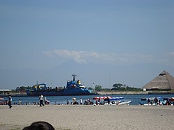
  Puerto Chiapas with mountains in the distance, 25 December 2008 | |
 Click on the map for a fullscreen view | |
| Location | |
| Country | Mexico |
| Location | Puerto de San Benito, Chiapas |
| Coordinates | 14°41′49″N 92°24′40″W / 14.697°N 92.411°W |
| Details | |
| Opened | 1975 |
| Operated by | Port Chiapas Port Authority |
| Type of harbour | bulk (coffee, minerals, gas), container, cruise |
| Size of harbour | 950 m × 350 m[1] |
| Land area | 60,000 square metres (15 acres) container storage[2] |
| No. of berths | 625 metres (2,051 ft)[1] |
| Director General | Alfonso Perez[3] |
| Statistics | |
| Annual revenue | $1.5 million (2009)[3] |
| Website www | |
The Port Chiapas (Spanish: Puerto Chiapas) is a port in Puerto de San Benito in the Tapachula municipality of the Soconusco region in the southern portion of the Mexican state of Chiapas. The port entrance lies about 13 kilometres (8.1 mi) northwest of the mouth of the Suchiate River which is the international boundary between Mexico and Guatemala. Puerto de San Benito is connected by Highway 225 to Tapachula International Airport and the city of Tapachula. Since its opening in 1975 the port has been a small fishing and agricultural transport center.[3] Upgrades carried out in 2005 and since by the government have added facilities for cruise ships and more heavy cargo.[4] Governor Juan Sabines Guerrero has ordered development of the port in the hopes it will attract business to Chiapas, currently the poorest state in Mexico.[3] Ships of the Holland America Line, Regent Seven Seas Cruises, Norwegian Cruise Line and Oceania Cruises currently arrives in Port Chiapas.[5][6]
Cruise information
There is little of interest to the cruise passenger in the immediate vicinity of the port. There is a craft market as one leaves the dock, but the nearest town, Tapachula, is a few miles inland.[7] Volcán Tacaná dominates the port's eastern horizon and a number of ruins and biological reservations are accessible from it.
Gallery
References
- ^ a b "Terminal de Carga" (in Spanish). Retrieved 2011-03-25.
- ^ "The Port of Chiapas receives the arrival of the Hapag Lloyd shipping line, as part of the scheduling stated on the containers trade route". 4 February 2011. Retrieved 2011-03-25.
- ^ a b c d Chiapas improves port for economic development.
- ^ Transportation and Ports in Mexico
- ^ Mexico Port Guide: Puerto Chiapas. cruisemates.com
- ^ "Luxury Cruise Vacations from Regent Seven Seas Cruises". Retrieved 10 April 2011.
- ^ Holland American Line, In Port: Puerto Chiapas (2011)


