
Praia Grande (Macau)
| Praia Grande Bay (Nam Van) | |
|---|---|
 | |
| Coordinates | 22°10′35″N 113°32′46″E / 22.17639°N 113.54611°E |
| Type | Bay |
| River sources | Pearl River |
| Ocean/sea sources | Pacific Ocean |
| Basin countries | China |
| Settlements | Macau Zhuhai |
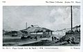
Praia Grande Bay (Template:Lang-pt or Chinese: 大灣; lit. 'large bay') or Nam Van (Chinese: 南灣; lit. 'south bay'), officially known as Ou Mun (Chinese: 澳門), is a bay in Macau, China. Located on the east side of the Macau Peninsula, it served as the chief promenade in Macau. It was the site of the governor's palace, the administrative offices, the consulates, and the leading commercial establishments.[1] It has been credited as probably the "most depicted view of 19th-century Macau",[2] and its most characteristic landmark for many years.[3] The bay was confined by the Fortress of St. Francis in the north-east and the Fortress of Bomparto in the south-west. Only a few colonial buildings remain, and the landscape has been largely altered by land reclamation and high-rise buildings.[2]
Gallery
-
 The Praia Grande (published 1843)
 -
 Praia Grande from the north, c. 1830
 -
 Praia Grande from the south, c. 1830
 -
 View of Praia Grande from a doorway on Penha Hill, 1834
 -
 Praia Grande, 1825–52


See also
References
- ^ The Encyclopædia Britannica (11th ed.). Volume 17. p. 191.
- ^ a b Lamas, Rosmarie W. N. (2006). Everything in Style: Harriett Low's Macau. Hong Kong University Press. p. 39. ISBN 9622097898.
- ^ Lee, Choy Khoon; Lee, Khoon Choy (2008). Passage Through China. China Knowledge Press. p. 558. ISBN 9814163430.