Province of Como
Province of Como | |
|---|---|
 | |
|
Coat of arms of Province of Como Coat of arms | |
 Map highlighting the location of the province of Como in Italy | |
| Country | |
| Region | Lombardy |
| Capital(s) | Como |
| Comuni | 160 |
| Government | |
| • President | Maria Rita Livio |
| Area | |
| • Total | 1,279 km2 (494 sq mi) |
| Population (1 January 2015) | |
| • Total | 599,905 |
| • Density | 470/km2 (1,200/sq mi) |
| Time zone | UTC+1 (CET) |
| • Summer (DST) | UTC+2 (CEST) |
| Postal code | 22100 |
| Telephone prefix | 031 0344 02 0331 |
| Vehicle registration | CO |
| ISTAT | 013 |
| Website | Official website |
The Province of Como (Italian: Provincia di Como; German: Provinz Como) is a province in the north of the Lombardy region of Italy and borders the Swiss cantons of Ticino and Grigioni to the North, the Italian provinces of Sondrio and Lecco to the East, the Province of Milan to the south and the Province of Varese to the West. The city of Como is its capital — other large towns, with more than 10,000 inhabitants, include Cantù, Erba, Mariano Comense and Olgiate Comasco. Campione d'Italia also belongs to the province and is enclaved in the Swiss canton of Ticino.
As of 30 April 2014[update], the main commune by population are:
| City | Population |
|---|---|
| Como | 85039 |
| Cantù | 39952 |
| Mariano Comense | 24116 |
| Erba | 16694 |
| Olgiate Comasco[1] | 11580 |
| Lurate Caccivio | 9911 |
| Fino Mornasco | 9818 |
| Lomazzo | 9,654 |
| Turate | 9,306 |
| Cermenate | 9,209 |
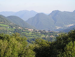
The Bergamo Alps and some hills cover the territory of the province, and the most important body of water is the glacial Lake Como.
See also
References
External links

