
Radium, Minnesota
Radium, Minnesota | |
|---|---|
 Radium, Minnesota  Radium, Minnesota | |
| Coordinates: 48°13′46″N 96°36′49″W / 48.22944°N 96.61361°W | |
| Country | United States |
| State | Minnesota |
| County | Marshall |
| Elevation | 925 ft (282 m) |
| Population | |
| • Total | 20 |
| Time zone | UTC-6 (Central (CST)) |
| • Summer (DST) | UTC-5 (CDT) |
| Area code | 218 |
| GNIS feature ID | 649789[2] |
Radium is an unincorporated community in section 19 of Comstock Township, Marshall County, Minnesota, United States.[2][1] It was built alongside the Minneapolis, St. Paul and Sault Ste. Marie Railroad (Soo Line Railroad) branch line built in 1905 from Thief River Falls, Minnesota, to Kenmare, North Dakota. (This line still operates under the aegis of the Northern Plains Railroad.) The place was named for the element radium.[3] Radium had its own post office from 1905 to 1984.[4] Since 1984, Radium has been served by the post office in Warren. It is also on the Warren telephone exchange and part of the Warren-Alvarado-Oslo school district. The townsite is being slowly reclaimed for use as farmland. There is still a large grain elevator on the railroad line south of the townsite. A small Lutheran church 1+1⁄2 miles (2.4 km) south of the town antedates the coming of the railroad; Immanuel Lutheran Church (LCMS) was organized in 1897.
Notes
- ^ a b Minnesota Department of Transportation-Marshall County
- ^ a b "Radium, Minnesota". Geographic Names Information System. United States Geological Survey, United States Department of the Interior.
- ^ Upham, Warren (1920). Minnesota Geographic Names: Their Origin and Historic Significance. Minnesota Historical Society. p. 330.
- ^ "Marshall County". Jim Forte Postal History. Retrieved 13 July 2015.
Municipalities and communities of Marshall County, Minnesota, United States | ||
|---|---|---|
| Cities | 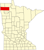 | |
| Townships |
| |
| Unincorporated communities | ||
| Unorganized territory | ||
| Indian reservation | ||
| Footnotes | ‡This populated place also has portions in an adjacent county or counties | |