
Rahumäe
Rahumäe | |
|---|---|
Subdistrict of Tallinn | |
 Former narrow gauge railway viaduct, now used by pedestrians. | |
 Rahumäe within Nõmme District. | |
| Country | |
| County | |
| City | |
| District | |
| Area | |
| • Total | 1.75 km2 (0.68 sq mi) |
| Population (01.01.2014[1]) | |
| • Total | 3,075 |
| • Density | 1,800/km2 (4,600/sq mi) |
Rahumäe (Estonian for "Quiet Hill") is a subdistrict (Estonian: asum) in the district of Nõmme, Tallinn, the capital of Estonia. It covers an area of 1.75 km2 (0.68 sq mi)[2] and has a population of 3,075 (As of 1 January 2014[update]),[1] population density is 1,695/km2 (4,391/sq mi).
Rahumäe has a station on the Elron western route.
Rahumäe and Jewish cemeteries are situated in Rahumäe.
Gallery
-
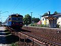
 Rahumäe train station
 -
-
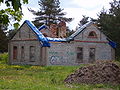 Ruins of former narrow gauge railway station building.

.jpg)

-
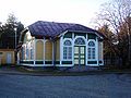
 Entrance of Rahumäe cemetery.
 -
 Chapel on Jewish cemetery
 -


References
- ^ a b "Statistical Yearbook of Tallinn 2014". Tallinn City Government. p. 52. Retrieved 27 November 2014.
- ^ "Nõmme linnaosa arengukava 2008-2012" (in Estonian). Tallinn http://www.tallinn.ee. p. 114. Retrieved 20 December 2009.
{{cite web}}: External link in|publisher=
Template:Estonia-train-station
Wikimedia Commons has media related to Rahumäe.
59°23′19″N 24°42′11″E / 59.388692°N 24.702952°E
Administrative districts (linnaosad) and subdistricts (asumid) of Tallinn | ||
|---|---|---|
| Haabersti |  | |
| Kesklinn | ||
| Kristiine | ||
| Lasnamäe | ||
| Mustamäe | ||
| Nõmme | ||
| Pirita | ||
| Põhja-Tallinn | ||
This Tallinn location article is a stub. You can help Wikipedia by expanding it. |