Rance Tidal Power Station: Difference between revisions
m Reverted edits by 170.185.165.19 (talk) to last version by Zorrobot |
|||
| Line 35: | Line 35: | ||
===Environmental Impact=== |
===Environmental Impact=== |
||
The barrage has caused progressive silting of the Rance ecosystem. [[Sand-eel]]s and [[plaice]] have disappeared, though [[Sea bass]] and [[cuttlefish]] have returned to the river. By definition, tides still flow in the estuary and the operators, EDF endeavours to adjust their level to minimize the biological impact. |
The barrage has caused progressive silting of the Rance ecosystem. [[Sand-eel]]s and [[plaice]] have disappeared, though [[Sea bass]] and [[cuttlefish]] have returned to the river. By definition, tides still flow in the estuary and the operators, EDF endeavours to adjust their level to minimize the biological impact. |
||
todd lawill |
|||
===Tourist attraction and a bridge=== |
===Tourist attraction and a bridge=== |
||
Revision as of 16:43, 28 October 2009
This article needs additional citations for verification. (June 2007) |


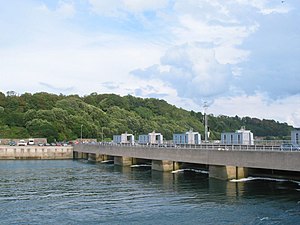
The Rance tidal power plant (Usine marémotrice de la Rance in French, Stankell vordredan ar Renk in Breton) was opened on the 26th November 1966 and is the world's first electrical generating station powered by tidal energy. It is located on the estuary of the Rance River, in Bretagne, France. It is operated by Électricité de France (EDF).
This may be one of the very few places in the world where this scheme can work because the power of the tides and the river Rance are used to pump water up into a basin during the times when the water levels are changing. The electricity is generated by a system identical to a hydro power installation where the water in the basin is sluiced down through the generators 24 hours a day to feed the EDF power grid. So, without a basin at an elevation higher than the barrage, it would not be feasible.
History
An early attempt to build a tidal power plant took place at Aber-Wrac'h in the Finistère in 1925, but due to financial problems, it was abandoned in 1930. The plans for this plant served as the draft for follow-on work. Use of tidal energy is not an entirely new concept; Tidal mills have long existed in areas affected by tides, in particular along the Rance.
The idea of constructing a tidal power plant on the Rance dates to Gerard Boisnoer in 1921. The site was attractive because there is a large average range between low and high tide levels (8 metres, with a maximum equinoctial range of 13.5 metres). The first studies which envisaged a tidal plant on the Rance were done by the Society for the Study of Utilization of the Tides (Société d'étude pour l'utilisation des marées [SEUM]) in 1943. Nevertheless, work did not actually commence until 1961. Albert Caquot, the visionary engineer, was instrumental in the construction of the dam, designing an enclosure in order to protect the construction site from the ocean tides and the strong streams.
Construction necessitated draining the area where the plant was to be built, which required construction of two dams; an effort which took two years. Construction of the plant proper commenced 20 July 1963, while the Rance was entirely blocked by the two dams.
Construction took three years and was completed in 1966. Charles de Gaulle, then President of France, inaugurated the plant on 26 November of the same year. Inauguration of the route crossing the plant took place 1 July 1967, and connection of the plant to the French national power grid (EDF)occurred on 4 December 1967.
In total, the plant cost 620 million Francs - roughly 94.5 Million Euros.[citation needed]
The plant produces 0.012% of the power consumed by France, with a peak rating of 240 Megawatts for its 24 turbines. Annual output is about 600 million kWh, or about 68MW average power.
Description
The barrage is 750 metres long, from Brebis point in the west to Briantais point in the east. It is located south of Dinard and Saint Malo, at the mouth of the river.
The power plant portion of the dam is 332.5 metres long. The tidal basin measures 22.5 km².
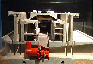
Turbines
The plant's turbines utilise the energy of the tides and the river current in turn; and as such are bi-directional.
Assessment
In spite of the high cost of the project, the plant's costs have now been recovered, and electricity production costs are lower than for nuclear power generation. (1.8c per kWh, versus 2.5c per kWh for nuclear)
Environmental Impact
The barrage has caused progressive silting of the Rance ecosystem. Sand-eels and plaice have disappeared, though Sea bass and cuttlefish have returned to the river. By definition, tides still flow in the estuary and the operators, EDF endeavours to adjust their level to minimize the biological impact. todd lawill
Tourist attraction and a bridge
The tidal power plant is of itself a tourist attraction which attracts 200,000 visitors per year. A canal lock in the west end of the dam permits the passage of 16,000 vessels between the English Channel and the Rance.
Departmental highway 168 crosses the dam and allows vehicles to travel between Dinard and Saint-Malo. There is a drawbridge where the road crosses the lock which may be raised to allow larger vessels to pass.
See also
External links
- University of Strathclyde Rance project case study
- EdF website in English
- French language web site on the Rance tidal power plant
- 2nd French language web site on the Rance tidal power plant
- 3rd French language web site on the Rance tidal power plant
48.61786°N -2.024617°E / 48.61786°N 2.024617°W Coordinates: longitude degrees < 0 with hemisphere flag
{{#coordinates:}}: invalid longitude
