
Rebun Island
 | |
| Geography | |
|---|---|
| Location | East Asia |
| Coordinates | 45°21′N 141°01′E / 45.350°N 141.017°E |
| Archipelago | Japanese Archipelago |
| Area | 80 km2 (31 sq mi) |
| Length | 29 km (18 mi) |
| Width | 8 km (5 mi) |
| Coastline | 72 km (44.7 mi) |
| Highest elevation | 490.0 m (1607.6 ft) |
| Administration | |
Japan | |
| Demographics | |
| Population | 3,194 |
| Pop. density | 39.3/km2 (101.8/sq mi) |
Rebun Island (礼文島, Rebun-tō; Ainu: Repun) is an island in the Sea of Japan off the northwestern tip of Hokkaidō, Japan. The island sits 50 kilometres (31 mi) off the coast of Hokkaidō. Rebun stretches 29 kilometres (18 mi) from north to south and 8 kilometres (5.0 mi) from east to west. The island covers approximately 80 square kilometres (31 sq mi). Rebun Island is located {{Convert|10|km|mi} northwest of Rishiri Island, and the two islands are separated by the Rebun Channel.[1][2][3]
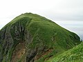
Rebun Island is known for its alpine flowers and the 8-Hour Hiking Course which runs from one end of the island to the other, north to south. The hiking course can be broken into two sections, known as the 4-Hour Hiking Courses. Rebun Island is home to a chashi, or hilltop fortifications of the Ainu people. The highest point on the island is Mount Rebun (490 metres (1,610 ft)).[2] The island is part of the Rishiri-Rebun-Sarobetsu National Park.
Etymology
The name of the island in the Ainu language, "Repun", means "island in the open sea."[1][2]
Areas of interest
- Mount Rebun
- Peach Rock, or Momoiwa
- Jizo Rock
- Cat Rock, or Nekoiwa
- Cape Sukoton
- Cape Kaneda
- Cape Gorota
- Cape Sukai
- Todo Island
- Lake Kushu
- Yamunai Valley
- Rebun Forest Road
- Rebun Falls
Communities
All communities on Rebun Island are part of the town of Rebun in Rebun District. From roughly from north to south, they are:[4]
- Sukoton
- Awabikoton
- Hamanaka
- Funadomari
- Horodomari
- Uedomari
- Nairo
- Kitousu
- Kafukai
- Kafuka
- Shiretoko
Transportation
- Ferry link to Rishiri Island, Wakkanai, and Otaru via Rishiri
- Air link to Wakkanai Airport
Gallery
-
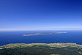 Rebun island (background) seen from Mount Rishiri
 -
 Lake Kusyu on Rebun island
 -
 Neko-iwa, 'cat rock'
 -
 Momo-iwa, 'peach rock'
 -
 Sukai Cape
 -
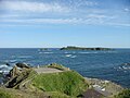 Sukoton Cape and Todo island


References
- ^ a b "礼文島". Dijitaru Daijisen (in Japanese). Tokyo: Shogakukan. 2012. OCLC 56431036. Retrieved 2012-08-27.
{{cite encyclopedia}}: Unknown parameter|trans_title=ignored (|trans-title=suggested) (help) - ^ a b c "礼文島". Nihon Kokugo Daijiten (in Japanese). Tokyo: Shogakukan. 2012. OCLC 56431036. Retrieved 2012-08-27.
{{cite encyclopedia}}: Unknown parameter|trans_title=ignored (|trans-title=suggested) (help) - ^ "礼文島". Nihon Daihyakka Zensho (Nipponika) (in Japanese). Tokyo: Shogakukan. 2012. OCLC 153301537. Retrieved 2012-08-22.
{{cite encyclopedia}}: Unknown parameter|trans_title=ignored (|trans-title=suggested) (help) - ^ Bisignani, J. D. (December 1993). "Dohoku-Northern Hokkaido". In Taran March (ed.). Japan Handbook (Second ed.). Chico, CA USA: Moon Publications, Inc. pp. 836–841. ISBN 0-918373-70-0.