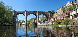
River Nidd
It has been suggested that Nidd Gorge be merged into this article. (Discuss) Proposed since August 2007. |
| River Nidd | |
|---|---|
 | |
| Physical characteristics | |
| Mouth | River Ouse, Nun Monkton |
The River Nidd is tributary of the River Ouse in the English county of North Yorkshire.
The Nidd rises in Nidderdale in the Yorkshire Dales. In its first few miles it is dammed twice to create Angram Reservoir and Scar House Reservoir, which attract around 150,000 visitors a year.
The first major settlement on the course of the river is Pateley Bridge. The Nidderdale Museum is located here, and features sections about the traditional agriculture, industries, religion, transport and costume of Nidderdale.
The river then passes to the north of Harrogate before flowing through Knaresborough, which is home to Knaresborough Castle and Knaresborough Museum.
The Nidd then continues east crossing underneath the A1 and the A1(M) near the small village of Cowthorpe, after which the river meanders towards its junction with the River Ouse at Nun Monkton.
Settlements
from source
- Lofthouse
- Ramsgill
- Wath
- Pateley Bridge
- Bewerley
- Glasshouses
- Summerbridge
- Dacre Banks
- Darley
- Birstwith
- Hampsthwaite
- Clint
- Killinghall
- Knaresborough
- Little Ribston
- Walshford
- Cowthorpe
- Cattal
- Moor Monkton
- Nun Monkton
(joins Ouse)
