Sai Ngam, Kamphaeng Phet
Sai Ngam
ไทรงาม | |
|---|---|
| Sai Ngam subdistrict ตำบลไทรงาม | |
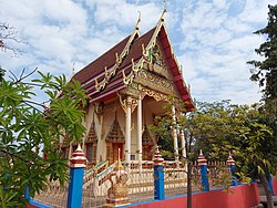
 Wat Thep Nimit Mongkhon | |
 | |
| Coordinates: 16°28′01.0″N 99°53′24.9″E / 16.466944°N 99.890250°E | |
| Country | |
| Established | 1969[1] |
| Subdivisions | 10 villages |
| Area | |
| • Total | 77.96 km2 (30.10 sq mi) |
| Population (2023)[2] | |
| • Total | |
| • Density | 114/km2 (300/sq mi) |
| Time zone | UTC+07 (TST) |
| Postal code | 62150 |
| Geocode | 620201 |
Sai Ngam (Thai: ไทรงาม, pronounced [sāj ŋāːm]) is a subdistrict in the middle part of Sai Ngam, Kamphaeng Phet, Thailand, with an estimated population of 8,900 in 2023. Founded by Luang Pu In (หลวงปู่อินทร์), a Buddhist monk who came from Nakhon Sawan along with his family in 1958. It shares boundaries with the subdistricts of Nong Mai Kong to the east, Nong Mae Taeng to the south, and Nong Khla and Maha Chai to the west. In the north it borders with the Lan Krabue district (Chong Lom and Non Phluang). Sai Ngam is divided into 10 villages and governed by two local administrative bodies.
Originally, Sai Ngam was the part of Nong Khla, Mueang Kamphaeng Phet, where located in the Reserve Forest area. By the late 1950s, many people from Thung Sai and Nakhon Sawan came to settle around a swamp known as Nong Sai (หนองทราย) and named the village after it. The name was later changed to "Sai Ngam", and it was separated from Nong Khla to become a subdistrict in 1958.
A large section of the center of the subdistrict, including buildings and homes, covering 5.1 square kilometres (2.0 sq mi), is part of Sai Ngam subdistrict municipality. The subdistrict serves as the economic and educational center of the district. Most of the population practices Theravada Buddhism and is engaged in agriculture.
Administration
[edit]Central administration
[edit]The tambon is subdivided into 10 administrative villages (muban).
| No. | Name | Thai |
|---|---|---|
| 1. | Ban Sai Ngam Nuea | บ้านไทรงามเหนือ |
| 2. | Ban Noen Sam Ran | บ้านเนินสำราญ |
| 3. | Ban Sai Ngam | บ้านไทรงาม |
| 4. | Ban Sai Ngam | บ้านไทรงาม |
| 5. | Ban Sai Ngam | บ้านไทรงาม |
| 6. | Ban Nong Mai Daeng | บ้านหนองไม้แดง |
| 7. | Ban Sai Ngam Tai | บ้านไทรงามใต้ |
| 8. | Ban Kaeo Chai Mongkol | บ้านแก้วชัยมงคล |
| 9. | Ban Tham Sadao | บ้านถ้ำสะเดา |
| 10. | Ban Dong Yen | บ้านดงเย็น |
Local administration
[edit]The area of the subdistrict is shared by 2 local governments.
- the subdistrict municipality (Thesaban Tambon) Sai Ngam (เทศบาลตำบลไทรงาม)
- the subdistrict administrative organization (SAO) Sai Ngam (องค์การบริหารส่วนตำบลไทรงาม)
References
[edit]- ^ "ประกาศกระทรวงมหาดไทย เรื่อง ตั้งและเปลี่ยนแปลงเขตตำบลในท้องที่อำเภอเมืองกำแพงเพชร และอำเภอพรานกระต่าย จังหวัดกำแพงเพชร" (PDF). Royal Gazette. 86 (49 ง): 1858–1862. June 3, 1969. Archived from the original (PDF) on July 25, 2021.
- ^ สถิติประชากรทางการทะเบียนราษฎร [Population statistics from the civil registration]. Registration Office Department of the Interior, Ministry of the Interior. stat.bora.dopa.go.th (in Thai). Retrieved 24 January 2021.
