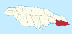
Saint Thomas Parish, Jamaica
Saint Thomas | |
|---|---|
 Saint Thomas in Jamaica | |
| Country | Jamaica |
| County | Surrey |
| Capital | Morant Bay |
| Major towns | Port Morant, Yallahs, Bath, Seaforth, Golden Grove |
| Area | |
• Total | 742.8 km2 (286.8 sq mi) |
| • Rank | 9 |
| Population (2012)[1] | |
• Total | 94,410 |
| • Density | 130/km2 (330/sq mi) |
Saint Thomas, once known as Saint Thomas in the East, is a suburban parish situated at the south eastern end of Jamaica, within the county of Surrey. It is the birthplace of the Right Honourable Paul Bogle, one of Jamaica's seven National Heroes. Morant Bay, its chief town and capital, is the site of the Morant Bay Rebellion, of which Bogle and George William Gordon were leaders.
Brief history
Saint Thomas was densely populated by the Taínos/Arawaks when Christopher Columbus first came to the island in 1494. The Spaniards established cattle ranches at Morant Bay and Yallahs. In 1655, when the English captured Jamaica, residents from other British colonies were invited to settle here. About 1600 colonists, mainly from Nevis – including the Governor of Nevis, his wife, children – settled there. In a short time, however, two-thirds of them died of fevers.
In 1674, the French Admiral Du Casse, sailed from Santo Domingo landing at Morant Bay on 17 June. For a month, he wrought havoc on local settlers, killing many and carrying off their slaves. Later, bands of Maroons settled in the mountains of St Thomas and they eventually joined with the Maroons in Portland to form the Windward Maroons.
Morant Bay rebellion
In 1865, Morant Bay rebellion took place in St Thomas. Ex-slaves all over Jamaica were discontented about the injustices being meted out to them, particularly on the question of land tenure. Paul Bogle led a delegation of small farmers who walked 72 kilometres (45 mi) to present their grievances to Governor Eyre in Spanish Town, but they were denied an audience. On 11 October, Paul Bogle and his followers armed with sticks and machetes went to the Court House where a vestry meeting was being held. The authorities read the Riot Act, but the protestors ignored it. A few people began to throw stones at the militia, who fired into the crowd killing seven people. Later the mob reorganized and returned, setting fire to the Court House and nearby buildings. When the custos, Maximillian von Ketelhodt, and others tried to leave the burning building, the mob killed them.
George William Gordon, who was in touch with Paul Bogle, tried to improve the lot of the workers by speaking out in the House of Assembly. However, he was taken by boat to Morant Bay, where he was tried for conspiracy and hanged on 23 October. The following day Bogle was captured by the Maroons, handed over to the authorities, and hanged.
More than 430 people were killed or executed by soldiers in the rebellion, and over 1,000 homes were burned to the ground. Public outcry led to the appointment of a Royal Commission to investigate events. In 1969, the Right Excellent Paul Bogle was named a National Hero, along with George William Gordon, Marcus Garvey, Sir Alexander Bustamante, and Norman Washington Manley.
Geography and Demography
Saint Thomas is located at latitude 18°05'N, longitude 76°40'W, to the south of Portland, and the east of St. Andrew. With an area of 742.8 square kilometres (286.8 sq mi), it ranks as Jamaica's ninth largest parish. It is a very mountainous parish, and the ranges include the Port Royal Mountains, stretching from above Newcastle in St Andrew, to Albion in St Thomas; the Queensbury Ridge, between Yallahs and Negro River; and to the extreme south, an isolated ridge called Yallahs Hill, with its highest elevation 730 metres (2,394 ft) above sea level. The Blue Mountains form its northern border.
The parish contains large wetland areas, comprising the coastal area between Morant Bay and Hector's River. There are also many cliffs and beaches.
There are three main rivers in the parish; the Yallahs River, 36.9 kilometres (22.9 mi) long, the Morant River, 21.9 kilometres (13.6 mi), and the Plantain Garden River, 34.9 kilometres (21.7 mi) long. The latter is the only one in the island to flow eastward.
The ethnic makeup of Saint Thomas is 88.2% black, 7.6% Asian, 3.2% white, and 1%other.
Commerce
Bauxite mining and tourism are the major source of Jamaica GDP. Agriculture plays a vital part in the economy. Sugar and bananas are the main items produced for export. Most small farmers produce domestic and orchard crops and this is the main source of employment. Serge Island Dairies are located in the parish. St. Thomas also has many factories for food processing and electrical equipment. Current efforts are being made by Upliftmentjamaica.org to create, support and provide opportunities to the people of St. Thomas, and to encourage economic and social transformation on a community and country-wide basis. Over 10,000 people benefit annually from this organization, via year-round projects and events, with numbers rapidly increasing.
Transportation
Roads
The coast of St. Thomas is skirted by the A4, which runs from Kingston to Annotto Bay. The primary secondary road runs east to west along the foot of the Blue Mountains from Golden Grove to Richmond Vale, with north-south connecting roads linking it to the A4 at Plesant Hill, Port Morant, Morant Bay, Church Corner, Belvedere, Yallahs, Albion and Eleven Mile.[2]
Rail
Rail transport in St. Thomas was formerly limited to estate light railways such as the one serving the former Bowden banana shipment port.[3] All are now closed.
Sea
The Morant Point Lighthouse guards the easternmost tip of the parish and the island.
See also
References
- ^ "Population by Parish". Statistical Institute of Jamaica. Retrieved 16 September 2015.
- ^ Esso 1:400,000 Road Map of Jamaica, 1967.
- ^ Aerial view.
