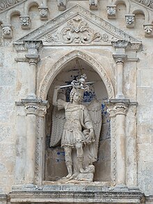
Sanctuary of Monte Sant'Angelo


The Sanctuary of Monte Sant'Angelo sul Gargano, sometimes called simply Monte Gargano, is a Catholic sanctuary on Mount Gargano, Italy, part of the commune of Monte Sant'Angelo, in the province of Foggia, northern Apulia.
It is the oldest shrine in Western Europe dedicated to the archangel Michael and has been an important pilgrimage site since the Middle Ages. The historic site and its environs are protected by the Parco Nazionale del Gargano.
In 2011, it became a UNESCO World Heritage Site as part of a group of seven inscribed as Longobards in Italy. Places of the power (568-774 A.D.).
History
The legend of the Archangel's apparition at Gargano is related in the Roman Breviary for May 8, as well as in the Golden Legend (Legenda Aurea), the compendium of Christian legend compiled by Jacobus de Voragine between 1260-1275.
According to this legend, around the year 490 the Archangel Michael appeared several times to the Bishop of Sipontum near a cave, asking that the cave be dedicated to Christian worship and promising protection of the nearby town of Sipontum from pagan invaders. These were the first apparitions of Michael in Western Europe.
Pope Gelasius I (reigned 492-496) directed that a basilica be erected enclosing the space. The Basilica di San Giovanni in Tumba is the final resting-place of the Lombard king Rothari (died 652); the designation "tumba" is now applied to the cupola on squinches.[1]
To Michael's dramatic later intercession, appearing with flaming sword atop the mountain, in the midst of a storm on the eve of the battle, the Lombards of Sipontum attributed their victory (May 8, 663) over the Greeks loyal to the Byzantine emperor, and so, in commemoration of this victory, the church of Sipontum instituted a special feast honoring the Archangel, on May 8, which then spread throughout the Catholic Church. Since the time of Pius V it has been formalized as Apparitio S. Michaelis although it originally did not commemorate the apparition, but the victory of the barbarian Lombards over the Orthodox Greeks.
Architecture
The complex of buildings consists of the Battistero di San Giovanni in Tumba, damaged in 1942, and the Church of Santa Maria Maggiore. The baptistery presents a rectangular storey on which rests an octagon supporting an elliptical section and a high drum that supports the cupola. The church erected in the eleventh century by Archbishop Leone stands upon the remains of an ancient necropolis. A few remnants attest to its once-rich fresco decoration.
The Castello was enlarged by the Normans upon an episcopal residence of Orso, Bishop of Benevento, to provide a suitable seat for the Honor Montis Sancti Angeli, further modified by Frederick II.[2] The massive, octagonal campanile was built in the late 13th century by Frederick II as a watchtower. It was turned into a bell tower by Charles I of Anjou.
Behind a forecourt the sanctuary presents a portico of two Gothic arches, the right one of 1395 by the local architect Simone, the left one a reconstruction of 1865. From the portico steps lead down to the low arched nave. The cavern can be accessed from a Romanesque portal, called the Portale del Toro ("Gate of the Bull"): the doors, in bronze, were made in Constantinople in 1076, the donation of an Amalfitan noble. They are divided in 24 panels portraying episodes of angels from the Old and New Testaments.
The archaic cavern opening to the left, with its holy well, is full of votive offerings, especially the 12th century marble bishop's throne supported on crouching lions.[3] Among the ex voto objects is a statue of the Archangel by Andrea Sansovino.
Pilgrimages
During centuries, millions of pilgrims went to Monte Sant'Angelo in order to visit the “Celestial Basilica”. Among the pilgrims who visited the Saint Michael Archangel Sanctuary were many popes (Gelasius I, Leo IX, Urban II, Alexander III, Gregory X, Celestine V, John XXIII as Cardinal, John Paul II), saints (Bridget of Sweden, Bernard of Clairvaux, Thomas Aquinas) emperors, kings and princes (Louis II of Italy, Otto III, Herny II, Matilda of Tuscany, Charles I of Naples, Ferdinand II of Aragon).
Also Francis of Assisi went to visit the Sanctuary, but feeling himself unworthy to enter the grotto, he stopped in prayer and meditation at the entrance, kissed and carved on a stone the sign of the cross in the form of “T” (tau).
The guardians
Since 13 July 1996, the pastoral care of Saint Michael Archangel Sanctuary has been given to the Congregation of Saint Michael the Archangel.
See also
- Saint Michael (Roman Catholic)
- Chaplet of St. Michael the Archangel
- Scapular of St. Michael the Archangel
- Antónia d'Astónaco
References
- Arnold, J.C. "Arcadia Becomes Jerusalem: Angelic Caverns and Shrine Conversion at Monte Gargano." Speculum vol. 75 (July 2000), pp. 567–88
- N. Everett, "The Liber de apparitione S. Michaelis in Monte Gargano and the hagiography of dispossession", Analecta Bollandiana 120 (2002), 364-391. (Argues that the Liber reflects conflict between the churches of Siponto and Benevento over control of the Gargano shrine, and that the Liber dates c.663-750).
Notes
- ^ "La Tomba di Rotari è un battistero del XII secolo con copertura a cupola (o Tumba)." [1]
- ^ Itinerari turistici Monte Sant' Angelo - Gargano
- ^ The votive offerings have been studied in Giovanni Battista Bronzini, Ex voto e Santuari in Puglia: 1. Il Gargano (Florence:Olschki) 1993.
External links
- ildiariomontanaro.it - la testata giornalistica di Monte Sant'Angelo, a cura dell'associazione culturale Obiettivo Gargano.
- santuariosanmichele.it
- Jacopus de Voragine, Golden Legend: Saint Michael
- Selected modern bibliography
- Virtual tour of the Sanctuary
- Monte Sant’Angelo & the Gargano Photos
