
Santiago do Cacém
Santiago do Cacém | |
|---|---|
Settlement | |
 | |
 Flag  Coat of arms | |
 | |
| Coordinates: 38°01′N 8°42′W / 38.017°N 8.700°W | |
| Country | |
| Region | Alentejo |
| Intermunic. comm. | Alentejo Litoral |
| District | Setúbal |
| Area | |
| • Total | 1,059.69 km2 (409.15 sq mi) |
| Population (2011) | |
| • Total | 29,749 |
| • Density | 28/km2 (73/sq mi) |
| Time zone | UTC±00:00 (WET) |
| • Summer (DST) | UTC+01:00 (WEST) |
| Website | www.cm-santiagocacem.pt |
Santiago do Cacém (Portuguese pronunciation: [sɐ̃tiˈaɣu ðu kɐˈsɐ̃j] or [sɐ̃tiˈaɡu du kɐˈsẽj]) is a municipality in Setúbal District in Portugal. The population in 2011 was 29,749,[1] in an area of 1059.69 km².[2]
The present[when?] mayor is Vitor Manuel Caro Proença, elected by the Unitarian Democratic Coalition. The municipal holiday is July 25.
Places of interest
- Harmonia Society
- Park Rio da Figueira
- Miróbriga Ruins
- Castelo de Santiago do Cacém
Parishes
Administratively, the municipality is divided into eight civil parishes (freguesias):[3]
- Abela
- Alvalade
- Cercal do Alentejo
- Ermidas-Sado
- Santiago do Cacém, Santa Cruz e São Bartolomeu da Serra
- Santo André
- São Domingos e Vale de Água
- São Francisco da Serra
-
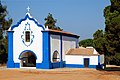 A local church depicting southern Portugal's typical charm.
 -
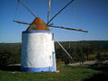 A local windmill.
 -
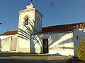 Another local church.
 -
 The local trainstation.
 -
 The local castle.
 -
 Mirobriga's Roman ruins.
 -
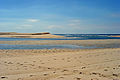 Santo André Lagoon.


International relations
Santiago do Cacém is twinned with:
![]() Santiago de Compostela, Spain
Santiago de Compostela, Spain
References
- ^ Instituto Nacional de Estatística
- ^ Direção-Geral do Território Archived 2014-09-29 at archive.today
- ^ Diário da República. "Law nr. 11-A/2013, pages 552 108-109" (pdf) (in Portuguese). Retrieved 30 July 2014.
External links
This Portugal location article is a stub. You can help Wikipedia by expanding it. |