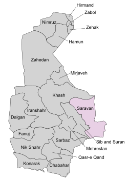
Saravan County
Appearance
Saravan County
Ŝahrestāne Sarāwān | |
|---|---|
 Location in Sistan and Baluchestan Province | |
 Location of Sistan and Baluchestan Province in Iran | |
| Coordinates: 27°20′N 62°00′E / 27.333°N 62.000°E | |
| Country | |
| Province | Sistan and Baluchestan |
| Capital | Saravan |
| Bakhsh (Districts) | Central District, Jaleq District, Bam Pasht District |
| Population (2006) | |
| • Total | 147,757 |
| Time zone | UTC+3:30 (IRST) |
| • Summer (DST) | UTC+4:30 (IRDT) |
| Saravan County can be found at GEOnet Names Server, at this link, by opening the Advanced Search box, entering "9206435" in the "Unique Feature Id" form, and clicking on "Search Database". | |
Saravan County (Template:Lang-fa) is a county in Sistan and Baluchistan in Iran, near to the international border of Pakistan. The capital of the county is Saravan. At the 2006 census, the county's population (including those portions of the county later split off to form Sib and Suran County and Mehrestan County) was 239,950, in 47,753 families; excluding those portions, the population was 147,757, in 28,218 families.[1] The county is subdivided into three districts: the Central District, Jaleq District, and Bam Pasht District. The county has five cities: Saravan, Sirkan, Gosht, Mohamadi and Jaleq.
References
- ^ "Census of the Islamic Republic of Iran, 1385 (2006)" (Excel). Statistical Center of Iran. Archived from the original on 2011-09-20.
- Iranian National Committee for Standardization of Geographical Names website (in Persian)
- Atlas Gitashenasi Ostanhai Iran] (Gitashenasi Province Atlas of Iran)

