
Serock
Serock | |
|---|---|
 Town hall | |
 Flag  Coat of arms | |
| Country | |
| Voivodeship | Masovian |
| County | Legionowo |
| Gmina | Serock |
| Established | 11th century |
| Town rights | 1417, 1923 |
| Government | |
| • Mayor | Sylwester Edwin Sokolnicki |
| Area | |
| • Total | 12.48 km2 (4.82 sq mi) |
| Elevation | 110 m (360 ft) |
| Population (2006) | |
| • Total | 3,721 |
| • Density | 300/km2 (770/sq mi) |
| Time zone | UTC+1 (CET) |
| • Summer (DST) | UTC+2 (CEST) |
| Postal code | 05-140 |
| Area code | +48 22 |
| Car plates | WL |
| Website | http://www.serock.pl |
Serock [ˈsɛrɔt͡sk] is a town at the north bank of the Zegrze lake in the Legionowo County, Masovian Voivodeship, Poland, with 3,616 inhabitants (2004).
Serock has existed as a fortified Masovian settlement since at least 1065. It was granted city rights in 1417 and again in 1923.
-
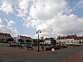 The market in Serock
 -
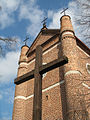
 The church in Serock
 -
 The church in Serock
 -
 Interior of the church
 -
 Jubilee Bell (AD 2000)


Jews in Serock
Before World War II, there was a significant Jewish population in Serock. Today there are no Jews. In the summer of 2000, a visiting descendant of former residents, discovered that a number of gravestones (Matzevot) were piled up in the city park [1]. The stones had been gathered by a local non-Jewish resident who also roped off the area. In 2006, a visit by members of the Jewish Records Indexing-Poland project confirmed the situation and now an attempt is being made to restore or at least establish a memorial on the site of the former Jewish cemetery. The United States Commission for the Preservation of America's Heritage Abroad [2] is involved under the guidance of The Honorable Lee R. Seeman.
External links
52°30′47″N 21°04′10″E / 52.51306°N 21.06944°E
This Legionowo County location article is a stub. You can help Wikipedia by expanding it. |