Shilka (river)
This article needs additional citations for verification. (June 2016) |
| Shilka River | |
|---|---|
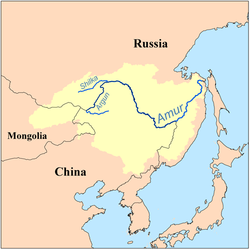
 Location of the Shilka River within the Amur Basin | |
| Location | |
| Country | Russia, Mongolia |
| Physical characteristics | |
| Length | 555 km (345 mi) |
| Basin size | 206,000 km2 (80,000 sq mi) |
| Discharge | |
| • average | 440 m3/s (16,000 cu ft/s) |

The Shilka (Russian: Ши́лка) is a river in Zabaykalsky Krai, south-eastern Russia. It has a length of 560 km (350 mi). It originates as a confluence of the Onon and Ingoda rivers. Its confluence with the Ergune on the Russia-China border gives rise to the Amur River. The river is navigable for its entire length. The name derives from Evenki shilki 'narrow valley.'[1]
Notes
- ^ E.M. Pospelov, Geograficheskie nazvaniya mira (Moscow: Russkie slovari, 1998), p. 473.
53°19′58″N 121°28′49″E / 53.33278°N 121.48028°E
