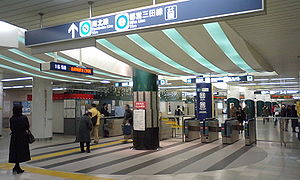
Shirokane-takanawa Station
N03 I03 Shirokane-takanawa Station 白金高輪駅 | |
|---|---|
 | |
| General information | |
| Location | 1 Chome-3-20 Takanawa, Minato, Tokyo Japan |
| Operated by | Tokyo Metro, Toei Subway |
| Line(s) | Tokyo Metro Namboku Line, Toei Mita Line |
| Other information | |
| Station code |
|
| History | |
| Opened | 2000 |
Shirokane-takanawa Station (白金高輪駅, Shirokane-takanawa-eki) is a subway station in Takanawa 1-chōme, Minato, Tokyo, Japan, jointly operated by the two Tokyo subway operators, Tokyo Metro and Toei Subway.
Lines
- Tokyo Metro Namboku Line (N-03)
- Toei Mita Line (I-03)
Namboku Line and Mita Line shares their lines between this station and Meguro station, the two lines' terminal. The trains from Meguro station either run into Namboku Line toward Azabu-juban, run into Mita Line toward Mita, or be terminated at this station.
Station layout
Tokyo Metro and Toei
The station consists of two island platforms serving four tracks. Mita Line uses the outer two tracks and Namboku Line uses the inner two tracks. Trains going northward uses platforms 1 and 2, ones going southward uses platforms 3 and 4, so that passengers can change their trains smoothly. The ticket gates are on the first basement floor and the platforms are on the third basement floor. The ticket gates are also shared with both Tokyo Metro and Toei. Passengers don't need to go through ticket gates to change their trains.
| 1 | ○ Mita Line | for Ōtemachi, Sugamo, and Nishi-Takashimadaira |
| 2 | ○ Namboku Line | for Nagatachō, Komagome, Akabane-Iwabuchi, and Urawa-Misono |
| 3 | ○ Namboku Line | for Meguro and Hiyoshi (via Tokyu Meguro Line) |
| 4 | ○ Mita Line | for Meguro and Hiyoshi (via Tokyu Meguro Line) |
Adjacent stations
History
The station opened on September 26, 2000.
