
Slate, Kansas
Slate, Kansas | |
|---|---|
| Coordinates: 39°28′50″N 99°31′38″W / 39.48056°N 99.52722°W | |
| Country | United States |
| State | Kansas |
| County | Rooks |
| Elevation | 2,172 ft (662 m) |
| Time zone | UTC-6 (Central (CST)) |
| • Summer (DST) | UTC-5 (CDT) |
| GNIS feature ID | 482003[1] |


Slate was a small settlement in Bow Creek Township, Rooks County, Kansas, United States.
History
Slate was located in Bow Township along Slate Creek.[2] A post office was issued to Slate in 1880. The post office was discontinued in 1903.[3] Population in 1910 was 36.[2]
References
- ^ "US Board on Geographic Names". United States Geological Survey. 1984-07-01. Retrieved 2017-12-30.
- ^ a b Blackmar, Frank Wilson (1912). Kansas: A Cyclopedia of State History, Volume 2, Chicago: Standard Publishing Company, p. 698
- ^ "Kansas Post Offices, 1828-1961". Kansas Historical Society. Retrieved 2017-12-30.
Municipalities and communities of Rooks County, Kansas, United States | ||
|---|---|---|
| Cities | 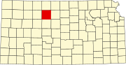 | |
| CDP | ||
| Unincorporated community | ||
| Ghost towns | ||
| Townships | ||
This article about a location in Rooks County, Kansas is a stub. You can help Wikipedia by expanding it. |