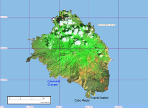
Socorro Island


Socorro Island (Spanish: Isla Socorro) is a volcanic island in the Revillagigedo Islands, a Mexican possession lying off that country's western coast at 18°48'N, 110°59'W. The size is 16.5 by 11.5 km, with an area of 132 km².
The island rises abruptly from the sea to 1130 meters in elevation at its summit. Mount Evermann is the name give to the summit dome complex. Isla Socorro is a shield volcano. It most recently erupted in 1993, which was an submarine flank eruption off the coast from Punta Tosca. Some of its earlier eruptions have been in ?1848, ?1896, 1905, and 1951.
The surface is broken by furrows, small craters, and numerous ravines. The island is covered by a dense growth of cactus and sage with some grass, but the vegetation in general is of a low order. The island is covered in lava domes, flows and cinder cones.
There is a naval station, established in 1957, with a population of 250 (staff and families), living in a village with a church, that stands on the western side of Bahia Vargas Lozano, a small cove with a rocky beach, about 800 meters east of Cabo Regla, the southernmost point of the island. There is a freshwater spring about 5 km northwest of Cabo Regla, at Ensenada Grayson (Caleta Grayson), an inlet.
No evidence of human habitation on Socorro exists before its discovery by Spanish explorers. Hernando de Grijalva and his crew discovered an uninhabited island on December 21 1533 and named it "Santo Tomé" (Spanish, "Saint Thomas"). In 1542, Ruy González de Villalobos, while exploring new routes across the Pacific, rediscovered "Inocentes" and changed its name to "Anublada" ("Cloudy"). In 1608, Martín Yañez de Armida, in charge of another expedition, visited Santo Tomé and changed its name to "Socorro" ("Help").
At the beginning of the twentieth century, Dr. Barton Warren Evermann, director of the California Academy of Sciences in San Francisco, California, promoted the scientific exploration of the island. The most comprehensive biological collections were obtained at this time. The volcano on Socorro was renamed in his honor.
The island was the home of the Socorro Dove, which is now extinct in the wild and survives only in a number of captive populations.
In September 1997, the island was struck by Hurricane Linda, one of the strongest hurricanes ever recorded.
Socorro Island is a popular scuba diving destination known for underwater encounters with dolphins, sharks, mantas and other pelagics. Since there is no public airport on the island, divers visit here aboard live-aboard dive vessels such as the 112' Solmar V out of Cabo San Lucas, Mexico. The most popular months are between November and May when the weather and seas are calmer.
References
- Template:VNUM
- Yarza de la Torre, Esperanza (1971). Volcanes de México. Aguilar. pp. 237 pp. (in Spanish)
