
Soriyankuppam
This article needs additional citations for verification. (August 2018) |
Soriyankuppam
Jothilingakuppam | |
|---|---|
Village | |
 Soriyankuppam Location in Puducherry, India  Soriyankuppam Soriyankuppam (India) | |
| Coordinates: 11°47′13″N 79°43′52″E / 11.787018°N 79.731045°E | |
| Country | |
| State | Puducherry |
| District | Pondicherry |
| Taluk | Bahour |
| Commune | Bahour |
| Population (2001) | |
| • Total | 36,983 |
| Languages | |
| • Official | French, Tamil, English |
| Time zone | UTC+5:30 (IST) |
| PIN | 607 402 |
| Telephone code | 0413 |
| Vehicle registration | PY-01 |
| Sex ratio | 50% ♂/♀ |
Soriyankuppam is a village[1] in Bahour Commune of Bahour taluk in the Union Territory of Puducherry, India. Soriyankuppam serves as a bypass for Puducherry - Panruti route via Savadi. It lies on southern tip of Bahour Enclave of Puducherry district.
Geography[edit]
Soriyankuppam is bordered by Irandairavilagam village of Tamil nadu in the west, Kuruvinatham in the north, Parikkalpattu in the east and Pennaiyar River in the south.
Road Network[edit]
Soriyankuppam is connected to Bahour, its Commune Headquarters via Kuruvinatham road. Cuddalore-Pallinelliyanur Major District Road (MDR) passes through Soriyankuppam. Soriyankuppam is directly connected to Puducherry by Puducherry - Soriyankuppam Bus route.
Gallery[edit]
-
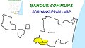 Map of Soriyankuppam Village Panchayat
 -
 Sooriyankuppam Village Panchayat Office, Bahour Commune
 -
 Anganvadi, Sooriyankuppam, Bahour Commune


Politics[edit]
Soriyankuppam is a part of Bahour (Union Territory Assembly constituency) which comes under Puducherry (Lok Sabha constituency)
References[edit]
- ^ "Archived copy" (PDF). Archived from the original (PDF) on 27 September 2013. Retrieved 17 March 2013.
{{cite web}}: CS1 maint: archived copy as title (link)