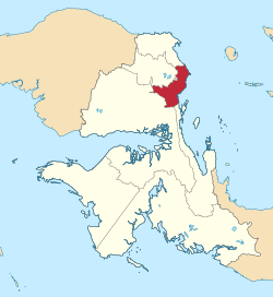
South Manokwari Regency
South Manokwari Regency
Kabupaten Manokwari Selatan | |
|---|---|
| Motto(s): Bersatu Membangun (Unite to Build) | |
 Location in West Papua | |
Location in Indonesia | |
| Coordinates: 1°04′47″S 133°58′02″E / 1.0798°S 133.9673°E | |
| Country | Indonesia |
| Province | West Papua |
| Capital | Ransiki |
| Government | |
| • Regent | Markus Waran |
| • Vice Regent | Wempy Rengkung |
| Area | |
| • Total | 2,812.44 km2 (1,085.89 sq mi) |
| Population (mid 2023 estimate)[1] | |
| • Total | 38,055 |
| • Density | 14/km2 (35/sq mi) |
| Time zone | UTC+9 (Indonesia Eastern Time) |
| Area code | (+62) 980 |
| Website | manselkab |
South Manokwari Regency is a regency of West Papua Province of Indonesia. It was formed in 2013 from the southern districts of Manokwari Regency, and covers an area of 2,812.44 km2. The population of the area now comprised in the new regency was 18,564 at the 2010 Census,[2] which rose to 35,949 at the 2020 Census;[3] the official estimate as at mid 2023 was 38,055 (comprising 19,600 males and 18,455 females).[1] The administrative centre is the town of Ransiki.
Geography[edit]
The geographical location of South Manokwari Regency can be seen according to its part as follows:
- North : 1º5' South Latitude;
- Southern Part : 2º5' South Latitude;
- West : 133º45' East Longitude; and
- East: 134º25' East Longitude.[4]
Administration[edit]
South Manokwari Regency is divided into six districts (distrik), listed below with their areas and their populations at the 2010 Census[2] and the 2020 Census,[3] together with the official estimates as at mid 2023.[1] The table also includes the location of the district administrative centres, the number of administrative villages (all classed as rural kampung) in each district and its post code.
| Kode Kemendagri |
Name of District (distrik) |
Area in km2 |
Pop'n Census 2010 |
Pop'n Census 2020 |
Pop'n Estimate mid 2023 |
Admin centre |
No. of villages |
Post code |
|---|---|---|---|---|---|---|---|---|
| 92.11.06 | Tahota | 604.15 | 581 | 1,051 | 1,084 | Yermatum | 4 | 98325 |
| 92.11.04 | Dataran Isim | 862.86 | 2,067 | 3,365 | 3,365 | Isim | 12 | 98326 |
| 92.11.03 | Neney | 249.55 | 1,193 | 2,872 | 3,217 | Neney | 7 | 98323 |
| 92.11.05 | Momi Waren | 456.18 | 2,030 | 5,060 | 5,726 | Demini | 7 | 98322 |
| 92.11.01 | Ransiki | 273.24 | 7,683 | 16,245 | 17,525 | Ransiki | 13 | 98324 |
| 92.11.02 | Oransbari | 366.46 | 5,010 | 7,356 | 7,138 | Waroser | 14 | 98321 |
| Totals | 2,812.44 | 18,564 | 35,949 | 38,055 | Ransiki | 57 |
References[edit]
- ^ a b c Badan Pusat Statistik, Jakarta, 28 February 2024, Kabupaten Manokwari Selatan Dalam Angka 2024 (Katalog-BPS 1102001.9211)
- ^ a b Biro Pusat Statistik, Jakarta, 2011.
- ^ a b Badan Pusat Statistik, Jakarta, 2021.
- ^ Direktorat Jendral Cipta Karya Kementerian Pekerjaan Umum dan Perumahan Rakyat, Jakarta, 2021


