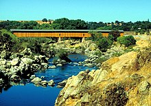
Stanislaus River


The Stanislaus River in California is one of the largest tributaries of the San Joaquin River. The river is 65 miles (104 km) long and has north, middle and south forks. The north and south forks meet several miles upstream from New Melones Lake and the middle fork joins the north fork a few miles before that. The Stanislaus river is extensively dammed and diverted. Donnells Dam on the middle fork forms Donell Lake, high in the Sierra Nevada. Downstream is Beardsley Dam, which forms Beardsley Lake. McKays' Point Diversion Dam diverts water on the north fork for hydroelectricity production and domestic use. The New Melones Dam blocks the river after the confluence of all three forks. Downstream from New Melones Lake, there is Tulloch Dam, which forms Tulloch Reservoir, and Goodwin Dam, located at 37°51′46″N 120°37′47″W / 37.86278°N 120.62972°W, which is the first major barrier for anadromous fish on the Stanislaus River. In fact, the Stanislaus River historically supported a large population of spring-run chinook salmon (McEwan 1996; Yoshiyama 1996) which was extirpated with the construction of Goodwin Dam. Below Goodwin Dam, the Stanislaus eventually meets the San Joaquin River and flows into the Sacramento-San Joaquin River Delta.
The Stanislaus is famous for a political battle over building the dam (which now forms New Melones Lake). Prior to the construction of the dam and the flooding of the river, the lower Stanislaus was one of the most rafted whitewater runs in the United States. Rafting is still popular on the north fork of the Stanislaus and on the Goodwin Canyon section of the main Stanislaus. In long periods of drought, the Camp Nine run comes back as the lake level drops. In the early 1990s, this section was runnable for 3 years, with the river reaching the Hwy 49 bridge before the rains brought the lake level all the way up above the put-in.
The river is named for Estanislao, a Miwok leader from Mission San José, who led a band of 400 former mission alcylotes against the Mexican government in 1828–1829. The band made its base along the banks of the river, then known as the Rio Laquisimes.
Covered bridges
Byrne's ferry bridge
One of the few remaining covered bridges in California crossed the Stanislaus River and was originally called the Byrne's Ferry bridge, named after the P. O. Byrne ferry which once crossed at the same point. Originally a chain cable suspension bridge with a plank floor, it was completed in the spring of 1853 and was opened to the public as a toll bridge. The suspension bridge was destroyed in the floods, and a new covered cantilever bridge of Howe truss type and reinforced by an auxiliary arch was built in 1862. Built and run by the Union Bridge Company, a corporation with headquarters at Sonora, Joe Pardies profitably operated the toll bridge for many years.
Frederick Russell Burnham, the celebrated scout, was largely responsible for the Byrne's Ferry bridge being purchased by the counties. In the late 1880s and early 1890s, Burnham was a cattleman in the region and during his annual summer trips into the mountains for better feed he drove his cattle across the bridge at a cost of $25 or $30 for the herd. Because he was dissatisfied with the condition of the bridge, and because he disliked paying the toll fee, Burnham circulated a petition for the bridge to be purchased by the two counties and to be made a free bridge. In 1902, the petition passed and the counties of Calaveras and Tuolumne purchased the bridge for $4,000 and the toll was discontinued.
It is claimed that the Californio bandit Tiburcio Vasquez held up the stage running between Chinese Camp and Copperopolis nearby. Wells Fargo posted a reward for his arrest and conviction and a posse was formed at Poker Flat which then crossed the Byrne's Ferry bridge in pursuit of the bandit. Vasquez escaped only to be captured later in San Jose, California and hanged not long after.
The Tri-Dam project and the Tulloch Reservoir eventually endend the story of the covered bridge. When filled to capacity, the reservoir backs river water up the canyon for seven miles and forms a large lake that covers the O'Byrne's Bridge site to a depth of eighty feet. In 1957, as the reservoir began to fill, the directors of the two irrigation districts studied the possibility of either burning the bridge where it stood or simply cutting it free from its moorings. But the Calaveras and Tuolumne County Historical Societies and the Copperopolis Community Club, assisted by the Native Sons of the Golden West and many other state-wide groups, took an interest in saving the bridge. They started what was known as a "DOLLAR" campaign to cover the cost of preserving the bridge as a future landmark; estimated at the time to be about $9,000. A plan was developed to move the bridge down-stream to a lagoon created by the reservoir where it could span an inlet and once again become a tourist attraction. The California State Parks Commission endorsed the proposal and a Tuolumne County rancher agreed to donate the property upon which the bridge could be located. However, such plans failed to materialize.
On the morning of October 21, 1957, the Calaveras and Tuolumne County supervisors sold the bridge at auction. Several attempts were made to blast the bridge from its supports using dynamite, but the charges were insufficient. As the water rose, the bridge eventually give up its supports but by then it was partially submerged. Unable to save the bridge, the structure was dismantled and some of the lumber was used to build the nearby resorts. About 3,000 feet upstream from where the old covered bridge stood, a new concrete and steel bridge was built in 1958 at a cost of $458,355.
References
"Old Corner" (html). Old Corner Saloon. Retrieved 2007-10-23.
