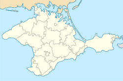
Stepove, Saky Raion, Crimea
Appearance
Stepove
Степове Qambar | |
|---|---|
 | |
| Coordinates: 45°09′00″N 33°53′48″E / 45.15000°N 33.89667°E | |
| Country | Disputed: |
| Oblast | |
| Raion | Saky Raion |
| Elevation | 101 m (331 ft) |
| 1 Autonomous Republic of Crimea (de jure) or Republic of Crimea (de facto), depending on jurisdiction. | |
Stepove (Ukrainian: Степове, romanized: Stepove; Crimean Tatar: Qambar) is a village in Saky Raion (district) in the Autonomous Republic of Crimea in southern Ukraine. It is about 27 km NW of Simferopol, and 24 km east of Saky. Following the 2014 annexation of Crimea, Stepove came under the control of Russia. Population: 361 (2014 Census).[2]
References
[edit]- ^ "Stepove (Saky Raion, Crimea)". weather.in.ua. Retrieved 20 July 2023.
- ^ Russian Federal State Statistics Service (2014). "Таблица 1.3. Численность населения Крымского федерального округа, городских округов, муниципальных районов, городских и сельских поселений" [Table 1.3. Population of Crimean Federal District, Its Urban Okrugs, Municipal Districts, Urban and Rural Settlements]. Федеральное статистическое наблюдение «Перепись населения в Крымском федеральном округе». ("Population Census in Crimean Federal District" Federal Statistical Examination) (in Russian). Federal State Statistics Service. Retrieved January 4, 2016.

