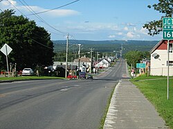
Stornoway, Quebec
Appearance
Stornoway | |
|---|---|
 Village of Stornoway | |
 Location within Le Granit RCM | |
| Coordinates: 45°43′N 71°10′W / 45.72°N 71.17°W[1] | |
| Country | |
| Province | |
| Region | Estrie |
| RCM | Le Granit |
| Constituted | January 1, 1858 |
| Government | |
| • Mayor | Pierre-André Gagné |
| • Federal riding | Mégantic—L'Érable |
| • Prov. riding | Mégantic |
| Area | |
• Total | 184.60 km2 (71.27 sq mi) |
| • Land | 180.15 km2 (69.56 sq mi) |
| Population | |
• Total | 535 |
| • Density | 3/km2 (8/sq mi) |
| • Pop 2016-2021 | |
| • Dwellings | 272 |
| Time zone | UTC−5 (EST) |
| • Summer (DST) | UTC−4 (EDT) |
| Postal code(s) | |
| Area code | 819 |
| Highways | |
| Website | www |
Stornoway, French: Stornoway, Scottish Gaelic: Steòrnabhagh is a small village of 500 people. It is a municipality in Quebec, in the regional county municipality of Le Granit in the administrative region of Estrie. It is named after Stornoway, a burgh on the Isle of Lewis, in the Outer Hebrides of Scotland by Colin Noble in 1852, replacing Bruceville.
It is at the intersection of two provincial highways, Route 108 and Route 161.
Demographics
[edit]| Year | 1861 | 1871 | 1881 | 1891 | 1901 | 1911 | 1921 | 1931 | 1941 | 1951 | 1956 | 1961 | 1966 | 1971 | 1976 | 1981 | 1986 | 1991 | 1996 | 2001 | 2006 | 2011 | 2016 | 2021 |
|---|---|---|---|---|---|---|---|---|---|---|---|---|---|---|---|---|---|---|---|---|---|---|---|---|
| Population | 800 | 702 | 944 | 705 | 684 | 863 | 909 | 913 | 1009 | 920 | 887 | 826 | 744 | 671 | 588 | 571 | 543 | 546 | 564 | 606 | 584 | 559 | 530 | 535 |
External links
[edit] Media related to Stornoway, Quebec at Wikimedia Commons
Former official website of Stornoway: "Municipalité de Stornoway". 2013-01-01. Archived from the original on 2013-01-01. (in French)
- Legendre Mill [dead link]
- Région du Lac-Mégantic (in French)
- Mégantic Region (in English)
- Stornoway (in French)
- Toponymy Commission of Quebec (in English)
- Affaires municipales et régions - cartes régionales (in French)
References
[edit]- ^ "Banque de noms de lieux du Québec: Reference number 60885". toponymie.gouv.qc.ca (in French). Commission de toponymie du Québec.
- ^ a b "Répertoire des municipalités: Geographic code 30105". www.mamh.gouv.qc.ca (in French). Ministère des Affaires municipales et de l'Habitation.
- ^ a b "Profile table, Census Profile, 2021 Census of Population - Stornoway, Municipalité (MÉ) [Census subdivision], Quebec". 9 February 2022.

