Strother Field
Strother Field (formerly Strother Army Airfield) | |||||||||||||||
|---|---|---|---|---|---|---|---|---|---|---|---|---|---|---|---|
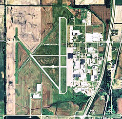
 USGS 2006 orthophoto | |||||||||||||||
| Summary | |||||||||||||||
| Airport type | Public | ||||||||||||||
| Owner | Cities of Winfield & Arkansas | ||||||||||||||
| Serves | Winfield / Arkansas City, Kansas | ||||||||||||||
| Location | Pleasant Valley Township / Beaver Township, Cowley County | ||||||||||||||
| Elevation AMSL | 1,160 ft / 354 m | ||||||||||||||
| Coordinates | 37°10′07″N 097°02′15″W / 37.16861°N 97.03750°W | ||||||||||||||
| Map | |||||||||||||||
 | |||||||||||||||
| Runways | |||||||||||||||
| |||||||||||||||
| Statistics (2008) | |||||||||||||||
| |||||||||||||||
Strother Field (IATA: WLD[2], ICAO: KWLD, FAA LID: WLD) is a public airport located in Cowley County, Kansas, United States.[1] It is located five nautical miles (6 mi, 9 km) southwest of the central business district of Winfield[1] and north of Arkansas City. The airport is jointly owned by both cities.[1] This airport is included in the National Plan of Integrated Airport Systems for 2011–2015, which categorized it as a general aviation facility.[3]
History
An airport, jointly owned by Arkansas City and Winfield, was under construction in April 1942 when the United States Army Air Forces indicated a need for the airfield as a training airfield by the Army Air Forces Flying Training Command, Gulf Coast Training Center. Strother Army Airfield was rushed to completion with the first class of cadets scheduled to arrive for basic training in the BT-13 on December 14, 1942.
The military use of Strother Field ended in October 1945 and it was turned over for civil use. Today, the site is currently Strother Field and Industrial Park. Remaining wartime structures include 2 hangars, 2 link training buildings, 1 tetrahedron wind cone, 2 ruins sites, 1 building of unknown original use and runways.
The airport is named for Donald Root Strother, the first Army Air Corp pilot from Cowley County, Kansas to lose his life in World War II. His older brother Dean C. Strother became a four-star general in the United States Air Force.[4]
Facilities and aircraft
Strother Field covers an area of 1,530 acres (619 ha) at an elevation of 1,160 feet (354 m) above mean sea level. It has two runways with asphalt surfaces: 17/35 is 5,506 by 100 feet (1,678 x 30 m) and 13/31 is 3,137 by 75 feet (956 x 23 m).[1]
Strother field's industrial park includes a jet engine maintenance and manufacturing facility for GE Aviation.
For the 12-month period ending November 19, 2008, the airport had 6,500 general aviation aircraft operations, an average of 17 per day. At that time there were 18 aircraft based at this airport: 83% single-engine, 11% ultralight, and 6% multi-engine.[1]
References
- ^ a b c d e f FAA Airport Form 5010 for WLD PDF. Federal Aviation Administration. Effective November 15, 2012.
- ^ "IATA Airport Code Search (WLD: Winfield / Arkansas City)". International Air Transport Association. Retrieved December 31, 2012.
- ^ "2011–2015 NPIAS Report, Appendix A" (PDF, 2.03 MB). National Plan of Integrated Airport Systems. Federal Aviation Administration. October 4, 2010.
{{cite web}}: External link in|work= - ^ Strother Army Air Field http://www.jcs-group.com/military/allyair/flying2.html
External links
- Strother Field Industrial Park, Winfield, Kansas
- Historical building inventory of Strother Field, 2008
- Aerial image as of March 1996 from USGS The National Map
- FAA Terminal Procedures for WLD, effective October 31, 2024
- Resources for this airport:
- FAA airport information for WLD
- AirNav airport information for KWLD
- ASN accident history for WLD
- FlightAware airport information and live flight tracker
- NOAA/NWS weather observations: current, past three days
- SkyVector aeronautical chart, Terminal Procedures

