
Svyetlahorsk
This article needs additional citations for verification. (December 2012) |
52°38′N 29°44′E / 52.633°N 29.733°E
Svietlahorsk[1]
Belarusian: Светлаго́рск | |
|---|---|
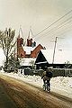
 In the center of town. | |
![Flag of Svietlahorsk[1]](/wiki/File:Flag_of_Svietlahorsk,_Belarus.png) Flag ![Official seal of Svietlahorsk[1]](/wiki/File:Coat_of_Arms_of_Sviet%C5%82ahorsk,_Belarus.png) Seal | |
| Country | |
| Voblasc | |
| Rajon | Svietlahorski |
| The first written mention | 1560 |
| Area | |
| • Total | 25.85 km2 (9.98 sq mi) |
| Elevation | 131 m (430 ft) |
| Population (2009) | |
| • Total | 69,995 |
| • Density | 2,796/km2 (7,240/sq mi) |
| [2] | |
| Time zone | UTC+3 (EET) |
| Postal code | |
| Area code | 375 (0) (2342) Template:Ref-ru |
| License plate | 3 |
| Website | Official website Template:Ref-ru |
Svietlahorsk (Belarusian: Светлаго́рск, [sʲvʲetɫaˈɣorsk], until 1961 Šacilki, Belarusian: Шацілкі) is a town in the Svietlahorski Rajon of Gomel Region of Belarus, the administrative center of the rajon (district). It is located by the river Biarezina and has 69,900 inhabitants (2010 estimate).
Industry
Within Svietlahorsk there are many industrial activities and organizations. They include: the power plant, a chemical man-made fiber plant, a reinforced concrete industrial complex, a Petroleum producing industry, a pulp and paper milk industry, butter-making factory, a bakery, and an industrial college.
Svietlаhorsk is also a railroad station on the Žlobin — Kalinkavičy railway line.
Sights
Within Svietlahorsk there is an Orthodox church and cathedral, a Catholic church, a quay, and a museum of local lore.
Health
Svietlahorsk is the region worst affected by HIV-AIDS in Belarus. Although the city accounts for less than 1% of the population of Belarus, it accounts for close to 30% of all the reported cases of HIV infections.[3][4] Around 6% of the adult population in Svietlahorsk is HIV positive.[5][6]
Twin towns
 Bielsk Podlaski.
 Călăraşi, Moldova.
 Călăraşi, Romania.
 Chernushka.
 Helmstedt.
 Ivanteyevka.
 Kingisepp.
 Kommunar.
 Obzor.
 Sliven.
 Mendip.
References
- ^ According to the Instruction on Latin Transliteration of Geographical Names of the Republic of Belarus (decree of the State Committee on Land Resources, Surveying and Cartography of the Republic of Belarus dated 11.06.2007 No. 38): Постановление Государственного комитета по имуществу Республики Беларусь от 11.06.2007 № 38 «О внесении изменений и дополнений в Инструкцию по транслитерации географических названий Республики Беларусь буквами латинского алфавита» // Национальный правовой интернет-портал Республики Беларусь. Template:Ref-ru
- ^ "World Gazetteer". Archived from the original on 2013-01-11.
- ^ Kostikova LI, Firsova NP, Vasilevskaia AE, Skripko SM, Serovkaia TI (1999). "Analiz vspyshki VICh-infektsii v g. Svetlogorske Respubliki Nelarus' sredi lits, potrebliaiushchikh narkotiki in ektsionno". Zhurnal Mikrobiologii, Epidemiologii, I Immunobiologii (in Russian) (1): 18–9. PMID 10096187.
{{cite journal}}: Unknown parameter|trans_title=ignored (|trans-title=suggested) (help)CS1 maint: multiple names: authors list (link) - ^ "Светлогорский зональный ЦГЭ - Эпидситуация по ВИЧ-инфекции в Гомельской области на 01.10.2012 года". Svetlcge.by. Retrieved 5 January 2015.
- ^ "10". - Govorim.by. Retrieved 5 January 2015.
- ^ [1] [dead link]
External links
- Рэгіянальны партал — Светлагорск (Svietlahorsk Regional Portal.)
- Светлагорск (Шацілкі) | Svietlahorsk (Šacilki) | Светлогорск (Шатилки) // Facebook
Gallery
-
 Orthodox Cathedral
 -
 Catholic parish church
 -
 Railway station
 -
City Hall


| Districts (raions) |  | |
|---|---|---|
| Cities and towns | ||