Tallebudgera, Queensland
Appearance
| Tallebudgera Gold Coast, Queensland | |||||||||||||||
|---|---|---|---|---|---|---|---|---|---|---|---|---|---|---|---|
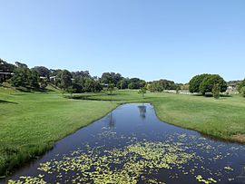
 Waterway along Tobin Way, 2015 | |||||||||||||||
| Population | 3,551 (2011 census)[1] | ||||||||||||||
| • Density | 197/km2 (511/sq mi) | ||||||||||||||
| Postcode(s) | 4228 | ||||||||||||||
| Area | 18 km2 (6.9 sq mi) | ||||||||||||||
| Location |
| ||||||||||||||
| LGA(s) | City of Gold Coast | ||||||||||||||
| State electorate(s) | Currumbin | ||||||||||||||
| Federal division(s) | McPherson | ||||||||||||||
| |||||||||||||||
Tallebudgera (meaning "good fish"),[2] originally known as Maybree,[2] is a suburb of the Australian city of Gold Coast. At the 2011 Australian Census the suburb recorded a population of 3,551.[1] The Tallebudgera Creek forms a part of the western and eastern border of Tallebudgera.
The traditional owners were the Tul-gi-gin people.[3] of Australian Aborigines, Indigenous Australians now account for just 0.9% of the population of Tallebudgera, around one third of the national average of 2.5%.[1]
Tallebudgera Golf Course is an 18-hole course at 495 Guineas Creek Road.
Heritage listings
Tallebudgera has a number of heritage-listed sites, including:
- 17 Trees Road: former Tallebudgera Post Office[4]
Education
References
- ^ a b c Australian Bureau of Statistics (31 October 2012). "Tallebudgera (State Suburb)". 2011 Census QuickStats. Retrieved 22 September 2014.
- ^ a b "Tallebudgera and Valley". Gold Coast City. Retrieved 31 October 2008.
- ^ [1]
- ^ "Tallebudgera Post Office (former) (entry 602624)". Queensland Heritage Register. Queensland Heritage Council. Retrieved 19 June 2013.
