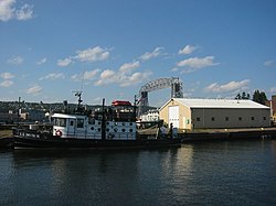
U.S. Army Corps of Engineers Duluth Vessel Yard
U.S. Army Corps of Engineers Vessel Yard | |
 U.S. Army Corps of Engineers Vessel Yard | |
| Location | Jct. of Ninth St., S. and Minnesota Ave. Duluth, Minnesota |
|---|---|
| Coordinates | 46°46′30.4″N 92°5′35″W / 46.775111°N 92.09306°W |
| Built | 1904 |
| NRHP reference No. | 95001163 [1] |
| Added to NRHP | October 23, 1995 |
The U.S. Army Corps of Engineers Vessel Yard in the U.S. city of Duluth was constructed between Lake Superior and Duluth's harbor, midway between Duluth and Superior, Wisconsin.
History
After the construction of the St. Mary's Falls Ship Canal was completed at Sault Ste. Marie, ships carrying grain, lumber, coal, and iron ore could carry the natural resources of the Midwest to East Coast ports. By the late 19th century the United States Army Corps of Engineers was tasked to create a bustling harbor at the western end of Lake Superior. For several years they created breakwaters, dredged channels, and built docks to accommodate ever-larger cargo-hauling ships. By the turn of the century, the Vermilion and Mesabi Iron Ranges were producing nearly 8 million long tons (8,100,000 Mg) of ore per year. The Corps was busy—between 1897 and 1902 they dredged 22 million cubic yards (17,000,000 cubic metres) out of the Duluth and Superior harbors, creating a 360-acre (0 km2) harbor with 17 miles (27 km) of ship channels. By 1906, the quantity of material shipped through the harbors was dominated only that of New York and Philadelphia.[2]
New location
In 1904, the Corps acquired its present site on the sandy spit of Minnesota Point, midway between Duluth and Superior. Few of the original buildings remain, but the mission continues—to keep the harbors open to increasingly larger ships.[2]
References
- ^ "National Register Information System". National Register of Historic Places. National Park Service. January 23, 2007.
- ^ a b Gardner, Denis P. (2004). Minnesota Treasures. Minnesota Historical Society Press. pp. 116–120. ISBN 0-87351-471-8.
