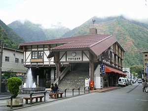
Unazuki Onsen Station
Unazuki Onsen Station 宇奈月温泉駅 | |
|---|---|
 Unazuki Onsen Station building | |
| General information | |
| Location | Unazuki, Kurobe, Toyama Japan |
| Operated by | Toyama Chihō Railway |
| Line(s) | Toyama Chihō Railway Main Line |
| History | |
| Opened | 1923 |
| Previous names | Momohara; Unazuki (until 1 August 1971) |
Unazuki Onsen Station (宇奈月温泉駅, Unazuki-onsen-eki) is a railway station in Unazuki, Kurobe, Toyama, Japan, operated by the private railway operator Toyama Chihō Railway. It is the terminus of the line. It is also located close to Unazuki Station on the narrow-gauge Kurobe Gorge Railway.
Lines
Unazuki Onsen Station is served by the Toyama Chihō Railway Main Line, and is located 53.3 km from the starting point of the line at Dentetsu Toyama.[1]
Station layout
The station has two tracks, ending with buffer stops. In former times, these tracks merged to enter a facility for loading and unloading narrow-gauge trucks with material for and from the construction of dams in the Kurobe River gorge.
Adjacent stations
| « | Service | » | ||
|---|---|---|---|---|
| Toyama Chihō Railway Main Line | ||||
| Toyama | Limited Express | Terminus | ||
| Otozawa | Rapid Express | Terminus | ||
| Otozawa | Express | Terminus | ||
| Otozawa | Local | Terminus | ||
History
The station opened on 21 November 1923, initially named Momohara Station (桃原駅).[1] This was renamed Unazuki Station (宇奈月駅) on 21 February 1924, eventually becoming Unazuki Onsen Station on 1 August 1971.[1]
