
Vilapakkam
Vilapakkam | |
|---|---|
town | |
| Country | |
| State | Tamil Nadu |
| District | Vellore |
| Population (2001) | |
| • Total | 8,053 |
| Languages | |
| • Official | Tamil |
| Time zone | UTC+5:30 (IST) |
Vilapakkam is a panchayat town in Vellore district in the Indian state of Tamil Nadu.
Demographics
As of 2001[update] India census,[1] Vilapakkam had a population of 8053. Males constitute 50% of the population and females 50%. Vilapakkam has an average literacy rate of 68%, higher than the national average of 59.5%: male literacy is 77%, and female literacy is 58%. In Vilapakkam, 11% of the population is under 6 years of age.Vilapakkam is situated to the south of Arcot in Vellore District. This town is around 25 km south-east of Vellore. Kavanur is in the west and Thimiri, on the Arcot -Arani Road, in the south. The hilly area locally known as Pancha Pandava Malai in Vilapakkam was a flourishing Jaina center during the early medieval period as it is evident from the rock cut cave temple, natural caverns with Jaina figures and inscriptions. The rock cut cave temple is a large excavation on the eastern lace of the huge hill.
-
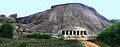 The Villapakkam Jain Rock Cut Cave
References
- ^ "Census of India 2001: Data from the 2001 Census, including cities, villages and towns (Provisional)". Census Commission of India. Archived from the original on 2004-06-16. Retrieved 2008-11-01.
12°51′43″N 79°17′32″E / 12.86194°N 79.29222°E
This article related to a location in Vellore district, Tamil Nadu, India is a stub. You can help Wikipedia by expanding it. |