Volkerak

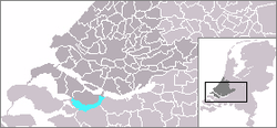
The Volkerak is a body of water in the Netherlands. It is part of the Rhine–Meuse–Scheldt delta, and is situated between the island Goeree-Overflakkee to the north-west and the Dutch mainland to the south and east. The western part of the Volkerak is also called Krammer.
Tributaries of the Volkerak are the Dintel and Steenbergse Vliet. The Volkerak is navigable by sea-going ships through the Volkerak Locks (Volkeraksluizen) from the Hollands Diep. The Scheldt–Rhine Canal connects it to the port of Antwerp.
Before 1967, it was a tidal river open to the North Sea, but it was closed off as part of the Delta Works, it is now a fresh water lake.
Futur
This lake is badly polluted, the turn over is 270 days which is too long. Swimming is prohibited. The decision to transform it again into a salt water lake could be taken between 2015 and 2020.
References
External links
51°39′N 4°18′E / 51.65°N 4.3°E
