
Wellsford, Kansas
Wellsford, Kansas | |
|---|---|
 Church in Wellsford (2006) | |
 | |
 Wellsford  Wellsford | |
| Coordinates: 37°37′00″N 99°01′43″W / 37.6166851°N 99.0287147°W[1] | |
| Country | United States |
| State | Kansas |
| County | Kiowa |
| Founded | 1880s |
| Incorporated | ? |
| Disincorporated | 1975 |
| Elevation | 2,116 ft (645 m) |
| Time zone | UTC-6 (CST) |
| • Summer (DST) | UTC-5 (CDT) |
| Area code | 620 |
| FIPS code | 20-76575 |
| GNIS ID | 474264 [1] |
Wellsford is an unincorporated community in Kiowa County, Kansas, United States.[1] It is located along Highway 54.
History[edit]
Wellsford had a post office from the 1880s until 1955.[2]
Previously, Wellsford was an incorporated city, but it disincorporated in 1975. Wellsford was incorporated in the 1910s and recorded a population of 140 in 1920. The population steadily declined thereafter, and in the last census taken while Wellsford was incorporated, in 1970, the town's population was only 9.[3]
Wellsford was the most recent Kansas town to be disincorporated until Treece was in 2012.
Today, the townsite contains a church and a historic one-room jailhouse from the late 1800s.
Geography[edit]
Wellsford is located at 37°37′00″N 99°01′43″W / 37.6166851°N 99.0287147°W (37.6166851, -99.0287147).[1]
Notable people[edit]
- Lloyd Stearman, aircraft designer and early aviation entrepreneur
References[edit]
- ^ a b c d e "Wellsford, Kansas", Geographic Names Information System, United States Geological Survey, United States Department of the Interior
- ^ "Kansas Post Offices, 1828-1961 (archived)". Kansas Historical Society. Archived from the original on October 9, 2013. Retrieved June 12, 2014.
- ^ "1940 Census - Kansas" (PDF). U.S. Census Bureau. Retrieved February 22, 2022.
Further reading[edit]
External links[edit]
Municipalities and communities of Kiowa County, Kansas, United States | ||
|---|---|---|
| Cities | 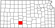 | |
| Unincorporated communities | ||
| Township | ||
This article about a location in Kiowa County, Kansas is a stub. You can help Wikipedia by expanding it. |