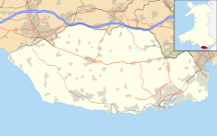
Welsh St Donats
Appearance
| Welsh St Donats | |
|---|---|
 St Donats (St Dunwyds) church | |
Location within the Vale of Glamorgan | |
| Population | 471 |
| Principal area | |
| Preserved county | |
| Country | Wales |
| Sovereign state | United Kingdom |
| Post town | Cowbridge |
| Postcode district | CF71 7 |
| Dialling code | 01446 |
| Police | South Wales |
| Fire | South Wales |
| Ambulance | Welsh |
| UK Parliament | |
| Senedd Cymru – Welsh Parliament | |
Welsh St Donats (Welsh: Llanddunwyd) is a village and a community in The Vale of Glamorgan, Wales. It is located North East of Cowbridge.
The electoral ward's population in 2011 was 471.[1] The community includes the villages of: Maendy, Prisk and Tair Onen.[2] A mile to the east from the village lies the Hensol Forest.
The church, St Dunwyd, is a Grade I listed building and was first mentioned in 1173.[3][4]
Notable people
See also
References
- ^ Office for National Statistics : Census 2011
- ^ http://www.welsh-st-donats-community.btck.co.uk/ Community website. Accessed 17 May 2014
- ^ http://www.eastvalechurches.org.uk /ChurchWelshStDonats.html East Vale Churches website. Accessed 17 May 2014.
- ^ "Church of St Donat, Welsh St Donats". British Listed Buildings. Retrieved 22 July 2015.
- ^ Jones, Sir Tom (2015). Over the Top and Back: The Autobiography. Penguin. ISBN 978-06984-0930-9.


