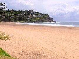
Whale Beach, New South Wales
Appearance
| Whale Beach Sydney, New South Wales | |||||||||||||||
|---|---|---|---|---|---|---|---|---|---|---|---|---|---|---|---|
 | |||||||||||||||
| Population | 315 (SAL 2021)[1] | ||||||||||||||
| Postcode(s) | 2107 | ||||||||||||||
| Location | 40 km (25 mi) north of Sydney CBD | ||||||||||||||
| LGA(s) | Pittwater Council | ||||||||||||||
| State electorate(s) | Pittwater | ||||||||||||||
| Federal division(s) | Mackellar | ||||||||||||||
| |||||||||||||||
Whale Beach is a northern beachside suburb of Sydney, in the state of New South Wales, Australia. Whale Beach is located 40 kilometres north of the Sydney central business district, in the local government area of Pittwater Council, in the Northern Beaches region.[2]
At the northern end of the beach, just off the rocks, a well-known surf break called the Wedge is located.
Whale Beach is the location of a distinctive home designed by the architect Alexander Stewart Jolly. Situated at Careel Head, overlooking Whale Beach, Careel House is a single storey bungalow made from sandstone blocks that were quarried at the site. It was built in 1931 and is heritage-listed.[3]
References
- ^ Australian Bureau of Statistics (28 June 2022). "Whale Beach (suburb and locality)". Australian Census 2021 QuickStats. Retrieved 28 June 2022.
- ^ Gregory's Sydney Street Directory (2002), Map 140
- ^ State heritage Website
External links
Photographs
33°36′46″S 151°19′38″E / 33.61269°S 151.32736°E
